ISSN ONLINE(2319-8753)PRINT(2347-6710)
ISSN ONLINE(2319-8753)PRINT(2347-6710)
Balamurugan.M1, Kalaiarasi.K2, Arun Prasad.S3
|
| Related article at Pubmed, Scholar Google |
Visit for more related articles at International Journal of Innovative Research in Science, Engineering and Technology
Agriculture continues to play a major role in Indian. With clear understanding of the soil type, fertility and other parameters related to agricultural yield, farmers can achieve better agricultural productivity. For sustainable agricultural development cultivable land information plays vital role. With detailed and reliable information, it is easier to implement better agricultural practices. With the development of sophisticated hardware and software systems, web mapping is extensively used by many organizations for their spatial data requirements. Several advancements in the system architecture and network designs facilitated enormous growth in web mapping and web cartography. Web GIS enable sharing geographical information with millions of users worldwide via internet. Agricultural Land Information System (ALSI) provides detailed information about demographic pattern of the area, spatial information, Agricultural land at various levels, road network, water Resources, soil characteristics, site characteristics and land suitability for crops at village level. This information will be very useful to the farmers, students, planners and decision makers for the integrated development of rural areas.
Keywords |
| ALSI, GIS, Web GIS, Web, Soil, Crops. |
INTRODUCTION |
| Agriculture continues to play a major role in India. Nearly 75 percent people are living in rural areas and are still dependent on Agriculture. About 43% of India’s geographical area is used for agricultural activity. The region has several hot spots of rural poverty, as most farmers in the region are small holders with diverse farming systems, which are highly risk prone. In addition, these farmers have poor access to support services such as extension, the agricultural Land information, knowledge, technology and financial credit. The new Agricultural Land Information System brings sustainable revolution by empowering the resource to poor farmers with up-to date knowledge and information about agricultural land and technologies, best practices, markets, price trends, consumer preferences, sources of finance, weather, soil-moisture conditions and the environment. |
| GIS software has enabled users to view spatial data in its proper format. As a result, the interpretation of spatial data becomes easy and increasingly simple to understand. Unfortunately, everyone does not know how to access GIS, and are not able to spend the time necessary to use it efficiently. Web GIS becomes a cheap and easy way of disseminating geospatial data and processing tools. Many organizations are interested to distribute maps and processing tools without time and location restriction to users. |
| Internet technology has made its way to many government organizations as well as numerous household. The ability to get information through internet made spatial data providers to explore the internet resources for disseminating spatial information. To provide a successful web GIS implementation it is required to consider the implementation as process rather than a step. The implementation should also respect the available technology and the application requirements. |
| The motivation behind this project is to develop a prefetching method for increasing the performance of Web GIS and responding the client requests in an acceptable period of time in a reasonable way. |
METHODOLOGY |
A. Study area Description |
| Sivagangai block is located on the Northwestern part of Sivagangai district (figure 1). The area lies between 78°19' and 78°33' East longitudes and 9°45' and 10°05' North latitudes. Total area of the block is 44660 hectares, which constitutes about 10.7 per cent of the area of the district. The block has 51 revenue villages. Village cadastral Maps and Soil statistical measures are used in this study. |
B. The ALSI Method |
| The architecture of our Web-tool is shown in (figure1) consisting of map services, data services, meta data and other information (e.g. photographs). |
| These included soil data from the Soil Survey Geographic Database (Natural Resource Service), land use/land cover and Land suitability for crops. |
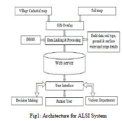 |
| We customized a GIS package in an intranet environment to meet the needs of the ALSI. The next stage was to include the new GIS functionalities in a restricted access website. The web pages are generated dynamically on the server side by retrieval of appropriate information from the constantly updated database. The website was built with CSS, HTML pages, PHP, Active Server Pages (ASPs). We have used Internet Information Server as web server. |
RESULTS AND DISCUSSION |
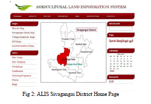
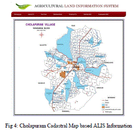
| A hardcopy of a cadastral map is taken to be scanned and digitized. The statistical soil data is integrated with the map and a soil map is drawn. Village cadastral map and soil maps have been prepared and all the maps are prepared in a scale of 1:5000. In the web page the main menu facilitate information services about maps, statistical datas.The modules include Maps, News, Site search,Tags and Calendar. |
 |
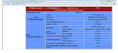
| The detailed information about the village can be viewed by all. The information includes |
| 1. Survey number |
| 2. Soil and site characteristics |
| 3. Suitable crops for cultivation |
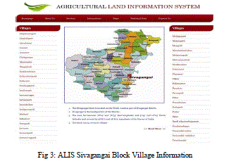 |
| It provides the facility to download the cadastral and soil maps for any given village in the sivagangai block. The pages allows the user to get the land suitability, soil & site characteristics data, Land suitability for various crops and horticultural crops of the particular survey number in a chosen villages. |
 |
 |
CONCLUSION |
| In this work a Web GIS (geographic information system) is used which provides a real time and dynamic way to represent information about Agricultural Land infrastructural facilities at village level through maps and statistics. It provides detailed information about demographic pattern of the area, spatial information, Agricultural land at various levels, road network, water Resources, soil and site characteristics and land suitability for crops at village level. |
| ALIS has been found to be extremely useful in mapping and planning of agricultural land information in sivagangai block of sivagangai district. This information will be very useful to the farmers, students, planners and decision makers for the integrated development of rural areas. The methodology developed can be used for district level too. Web GIS framework has been developed for spatial planning of infrastructural facilities in rural areas of sivagangai district. The farmers, planners and decision-makers who do not have in depth knowledge of GIS functioning can also use the developed Web GIS to improve the efficiency of planning process in sivagangai district. |
| This project is providing the web based Agricultural information's on soil characteristics and Land suitability for different types of Crops. This system will solve the decision making problem very much in agricultural economics research through web based. |
| This ALIS will be useful for different organizations like soil survey department and agricultural department in order to make an efficient system for agricultural management activities. |
References |
|