Satellite images need to be classified for surveillance purposes. The image obtained from the satellite should be classified properly in order to obtain the fine details of the image. Two method of image classification techniques are available they are supervised image classification and unsupervised image classification. Partitioning satellite image into meaningful regions has played an important role in recent years. The combination of topic models and random fields has been successfully applied to image classification because of their complementary effect. The supervised image classification needs manual interpretation with plentiful and expensive human effort. We proposed an efficient unsupervised image classification method for the classification of satellite images. The methods used are Latent Dirichlet Allocation and Markov Random field .The classification or segmentation obtained from the Latent Dirichlet Allocation method is more reliant on content coherence. The annotation performance of large satellite images is the benefit obtained from the topic models. The Markov Random Field method is used to obtain the spatial information between the neighbouring regions in the image. The combined models are complementary and the segmentation accuracy is improved. The iterative algorithm is proposed to make the number of classes finally be converged to appropriate levels. This is based on label cost and Bayesian information criterion .The whole process works automatically instead of assuming it beforehand as a constant.
Keywords |
| Latent Dirichlet Allocation (LDA), Unsupervised image classification, Markov Random Field |
INTRODUCTION |
| Remote sensing is the acquisition of information about the object without making physical contact with the
object. The term generally refers to the use of aerial senor technologies to detect and classify object on the earth by
means of propagated signals such as electromagnetic radiated emission from the satellite remote sensing makes it
possible to collect data on dangerous or inaccessible areas. |
| The process of remote sensing is also helpful for city planning, archaeological investigations, military
observation and geomorphologic surveying Partitioning satellite image into meaningful region has played an important
role in recent years. The supervised classification method includes manual interpretation which needs plentiful and
expensive human effort. One of the most challenging problems in remote sensing application is an automatic and
efficient method for image semantic extraction. In order to achieve an efficient content extraction of satellite images,
many clustering algorithms directly based on image features have been proposed the intent of the classification process
is to categorize all pixels in a digital image into one of several land cover classes or themes. This categorized data may
then be used to produce thematic maps of the land cover present in an image. |
| The objective of image classification is to identify and portray, as a unique gray level, the features occurring in
an image in terms of the object or type of land cover these features actually represent on the ground. Two main
classification methods are Supervised Classification and Unsupervised Classification. |
| Supervised classification method includes manual interpretation which needs plentiful and expensive human
effort. One of the most challenging problems in remote sensing application is an automatic and efficient method for
image semantic extraction. In order to achieve an efficient content extraction of satellite images, many clustering
algorithms directly based on image features have been proposed. |
| Unsupervised classification is a method which examines a large number of unknown pixels and divides into a
number of classed based on natural groupings present in the image values. Unlike supervised classification,
unsupervised classification does not require analyst-specified training data For questions on paper guidelines, please contact the conference publications committee as indicated on the conference website. Information about final paper
submission is available from the conference website. |
RELATED WORK |
| Classification of remotely sensed data is used to assign corresponding levels with respect to groups with
homogenous characteristics. The aim of discriminating multiple objects from each other with in the image The different
methods are used to achieve this. In [1] the combined spatial and aspect model significantly improves the region level
classification accuracy. In [2] the concept used is maximum likelihood method in order to efficiently handle the tasks
of image analysis related to content information of remote sensing many techniques based on clustering is used. In [3]
the application of alpha expansion algorithm in minimizing the energy is extended so that it can simultaneously
optimize label costs. In [4] weakly supervised classification method is used for a large PolSAR imagery using
multimodal markov aspect model, In [5] Probabilistic Latent Semantic Analysis (pLSA) method which was originally
used for text analysis is extended to images. Like a document contains topics images contains objects. This was the
analogy used for extension of PLSA algorithm from text to images. In [6] the visual vocabulary is an intermediate level
representation which has been proved to be very powerful for addressing object categorization problems. It is here to
embed the visual vocabulary creation within the object model construction, allowing to make it more suited for object
class discrimination and therefore for object categorization. In [7] statistical pattern recognition is integrated with
geosciences a new method ISODATA-Geosciences Imagery Classification method is used. In [8] ISODATA method
was executed in parallel using map reduce method thus execution time is considerably reduced. In [9] a new method is
for the subpixelic land cover classification using both high resolution structural information and coarse resolution
temporal information. In [10] an object oriented semantic clustering algorithm for high spatial resolution remote
sensing images using the probabilistic latent semantic analysis model coupled with neighbourhood spatial information. |
PROPOSED SYSTEM |
| The main objective is to obtain accurate segmentation results which can be obtained only by including spatial
information between pixels for calculation. Latent Dirichlet Allocation (LDA) method can do better segmentation but it
lacks spatial information. We propose a Segmentation method by combining LDA with Markov Random fields (MRF)
to for accurate segmentation results. |
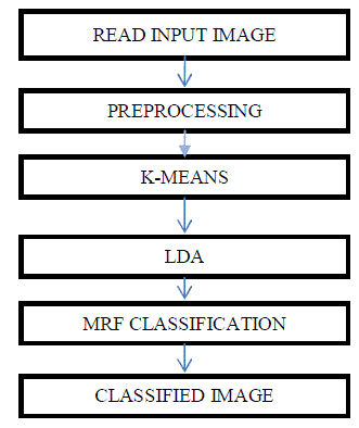
MODULE DESCRIPTION |
| Read Input Image: Input image is obtained from Google Earth |
| Preprocessing: In pre-processing two steps can be performed. The first step is the input image is resized and in the
second step the resized image is converted division of blocks. To extract the features we use Scale Invariant Features
transform (SIFT). |
| K-Means Quantization: The extracted features in the scale invariant features transform is then grouped using the kmeans
quantization. The k-means algorithm takes as input the number of clusters to generate k, and a set of observation
vectors to cluster. It returns a set of centroids, one for each of the k clusters. An observation vector is classified with the
cluster number or centroid index of the centroid closest to it. The result of k-means, a set of centroids, can be used to
quantize vectors. Quantization aims to find an encoding of vectors that reduces the expected distortion. |
| Latent Dirichlet Allocation: LDA allows sets of observations to be explained by unobserved groups that explain why
some parts of the data are similar. LDA is used to assign regions to pixels. |
| Markov Random Field: MRF which is undirected and cyclic is used to add spatial information for accurate
segmentation |
RESULT |
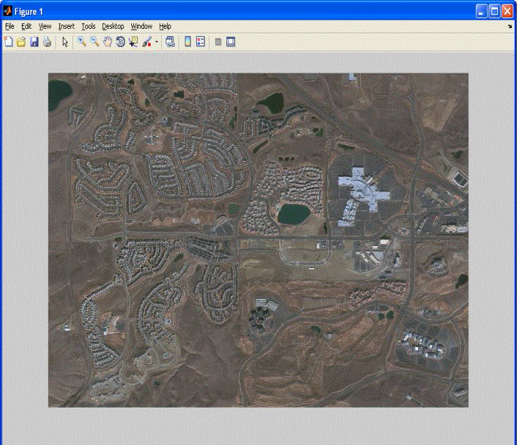
| INPUT IMAGE: The scene of input satellite image is derived from the Google Earth. |
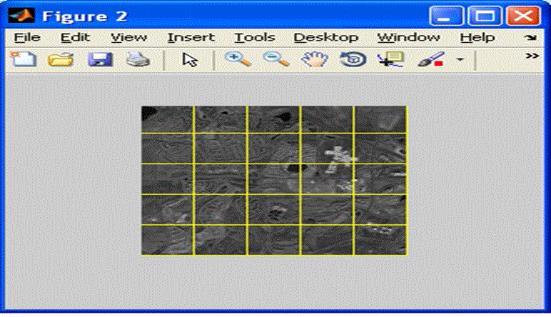
| FEATURE BASED SEGMENTATION: The input image obtained from the satellite is segmented based on the features.
The input image obtained from the satellite are segmented based on the features .first the input image is resized and
then the resized image is converted into division of blocks. To extract the features the Scale Invariant Feature
Transform is used. It is an algorithm used to detect and describe local features in an image |
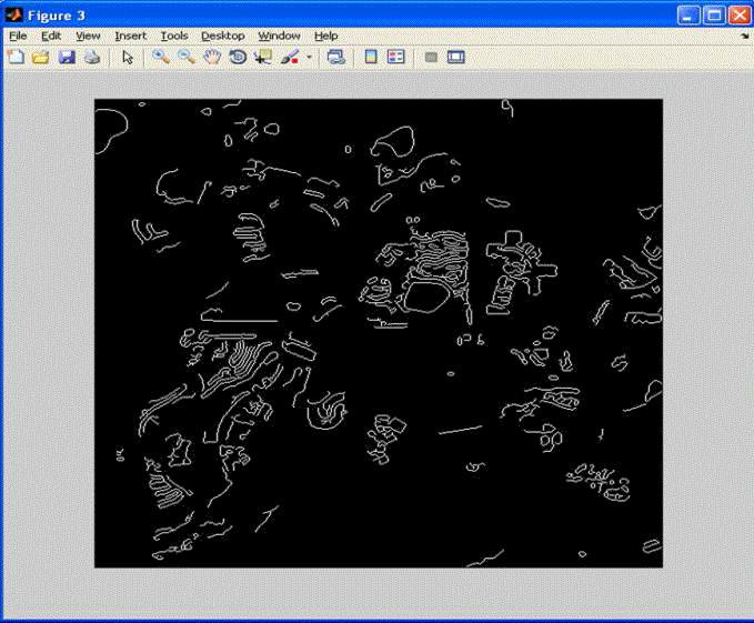
| EDGE DETECTION: |
| The output of edge detection is sown in fig 4 .The edge is detected using the canny edge detection method. It is a
multistage algorithm to detect various edges in an image. |
| LDA Classification(Existing): |
| The image is classified based on Latent Dirichlet Allocation method. The accurate segmentation of image is
not done in LDA. The disadvantage is lack of spatial correlation .To overcome this disadvantage we are going for
combined method classification called LDA and MRF classification |
| LDA-MRF Classification: |
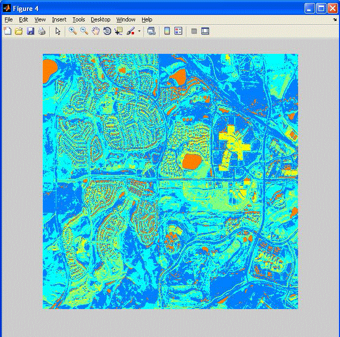
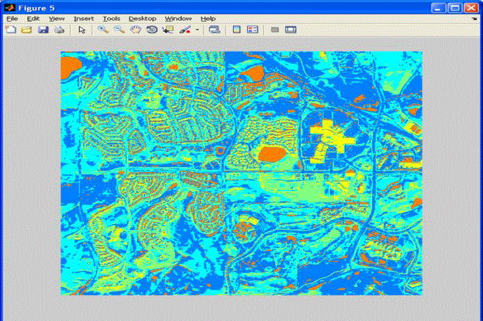
| This is the result obtained for LDA-MRF classification. The disadvantages of LDA MRF model were
overcome by capturing the local correlation between all spatially adjacent neighbors. It is an effective way to solve lack
of spatial information. Combining topic model with MRF is to compensate the loss of contextual information |
CONCLUSION |
| Thus the proposed LDA-MRF based Satellite Image Classification obtains images with high segmentation accuracy
and less computational complexity. Image Classification is done for LDA-MRF Method, In Future this Image
Classification can be done using support vector machine with radial basis function kernel method. |
| |
Figures at a glance |
 |
 |
 |
| Figure 1 |
Figure 2 |
Figure 3 |
 |
 |
 |
| Figure 4 |
Figure 5 |
Figure 6 |
|
| |
References |
- JakobVerbeek and Bill Triggs, âÃâ¬ÃÅRegion Classification with Markov Field Aspect ModelsâÃâ¬ÃÂ, IEEE, 2007.
- LiÃÆénou, MaÃÆître, and Datcu, âÃâ¬ÃÅSemantic annotation of satellite images using latent Dirichlet allocationâÃâ¬ÃÂ, IEEE Geosci. Remote Sens. Lett., vol. 7, no. 1, pp. 28âÃâ¬Ãâ32, Jan. 2010.
- Delong, Osokin, H. Isack, and Boykov, âÃâ¬ÃÅFast approximate energy minimization with label costsâÃâ¬ÃÂ, Proc. IEEE Conf. Comput. Vis. Pattern Recog., pp. 2173âÃâ¬Ãâ2180,2010.
- Yang, Dai, Wu, and He, âÃâ¬ÃÅWeakly supervised polarimetric SAR image classification with multi-modal Markov aspect model,âÃâ¬Ã in Proc. ISPRS, TC VII Symp. (Part B), 100 Years ISPRSâÃâ¬ÃâAdvancing Remote Sensing Science, Vienna, Austria, Jul. 5âÃâ¬Ãâ7, pp. 669âÃâ¬Ãâ673,2010.
- Andrew Zisserman and Xavier, âÃâ¬ÃÅ SceneClassication via pLSAâÃâ¬ÃÂ, IEEE, 2009.
- Diane Larlus, âÃâ¬ÃÅLatent mixture vocabularies for object categorization and segmentationâÃâ¬ÃÂ, IEEE, 2009
- YaojieYue and Qinqing, âÃâ¬ÃÅA Composed Statistical Pattern Recognition and Geosciences Analysis Approach for Segmentation based Remotely Sensed Imagery ClassificationâÃâ¬ÃÂ, 2008.
- Hui Zhao and Zhenhua, âÃâ¬ÃÅParallel ISODATA Clustering of Remote Sensing Images Based on Map ReduceâÃâ¬ÃÂ, IEEE, 2010.
- Amandine and Lionel Moisan, âÃâ¬ÃÅUnsupervised Subpixelic Classification Using Coarse Resolution Time Series and Structural InformationâÃâ¬ÃÂ, IEEE, 2008.
- Wenbin and Hong, âÃâ¬ÃÅAn Object Oriented Semantic Clustering Algorithm for High Resolution Remote Sensing Images using the Aspect ModelâÃâ¬Ã IEEE, 2011.
- Yi, Tang, and Chen, âÃâ¬ÃÅAn object-oriented semantic clustering algorithm for high-resolution remote sensing images using the aspect model,âÃâ¬Ã IEEE Geosci. RemotSens. Lett., vol. 8, no. 3, pp. 522âÃâ¬Ãâ526, May, 2011.
- Larlus and Jurie, âÃâ¬ÃÅLatent mixture vocabularies for object categorization and segmentation, Image Vis. ComputâÃâ¬ÃÂ, vol. 27, no. 5, pp. 523âÃâ¬Ãâ534, Apr. 2009.
- Bo Li, Hui Zhao and Zhen Hua, âÃâ¬ÃÅParallel ISODATA Clustering of Remote Sensing Images Based on MapReduceâÃâ¬ÃÂ, International Conference on Cyber-Enabled Distributed Computing and Knowledge Discovery, 2010.
- YaojieYue and Qinqing Shi, âÃâ¬ÃÅA Composed Statistical Pattern Recognition and Geosciences Analysis Approach for Segmentation based Remotely Sensed Imagery ClassificationâÃâ¬Ã , IEEE, 2011
- SudheendraVijayanarasimhan and Kristen Grauman, âÃâ¬ÃÅPredicting Effort vs. Informativeness for Multi-Label Image AnnotationsâÃâ¬ÃÂ, IEEE, 2009.
|