ISSN ONLINE(2319-8753)PRINT(2347-6710)
ISSN ONLINE(2319-8753)PRINT(2347-6710)
S.S.V.S.Ramakrishna1, V.Lakshmana Rao2,C.V.Srinivas3,N.Nagendra4 and K.B.R.R.Hariprasad5
|
| Related article at Pubmed, Scholar Google |
Visit for more related articles at International Journal of Innovative Research in Science, Engineering and Technology
Field experimental observations from GPS Radiosonde, 3 meteorological towers and 16 automated weather stations were employed to validate boundary layer wind field simulations made with Weather Research and Forecasting (ARW) model in the tropical coastal Kalpakkam region in southern India during the Round Robin Exercise (RRE) field experiment period (14 -24 September 2010). Three nested domain with high resolution (18,6,2 km resolution) with 45 vertical levels are used. Four planetary boundary layer physics schemes [Yonsei University Scheme(YSU), Mellor-Yamada-Nakashini (MYN), Mellor-Yamada-Janjc and Asymmetric Convective Model (ACM2)] were tested. Model evaluations with available data indicated better simulation results with the Yonsei University scheme (YSU) PBL scheme. Simulations for the 10days period in 14-25 Sep'10 indicate that the model reproduces the trends in surface temperature, humidity, and winds with a reasonable good comparison with observations at most places. Overall, the model produced slightly warmer temperatures (MAE=1.2 C), slightly stronger winds (MAE= 1.75 ms-1) and with overestimation of winds by 15%. These simulations are reasonably good for air pollution dispersion application.
Keywords |
| Wind field, Coastal meteorology, ARW model] |
INTRODUCTION |
| A study of coastal meteorology is important as several atmospheric phenomena in coastal regions influence turbulent diffusion, convective thunderstorms and local weather. The coastal weather systems are influenced by the coastal mesoscale processes that develop due to the land-ocean thermal contrast and topography variation. Increasing industrial growth and population expansion in coastal areas necessitates accurate air pollution dispersion estimates. The regional and local scale meteorological conditions and prevailing winds influence the pollutant trajectories and ground level concentrations. Pollutant plumes in the coastal zones are influenced by development of mesoscale sea breeze circulations that develop due to differential heating of the land and water surfaces (Pielke et al ., 1991; Lu et al., 1995). Differential land-sea temperatures and the incidence of local circulations initiate development of internal boundary layer (IBL), which has a critical effect on dispersion (Luhar et al., 1998; Lu et al ., 2001). These local effects need to be accounted in the coastal dispersion simulation for realistic estimations of pollutant concentrations. Accurate meteorological inputs are required to obtain realistic estimation of concentrations. Numerous studies shows that the spatial and temporal resolution of meteorological data is an important factor for the accurate estimation of plume trajectories and concentration (Brost, et al ., 1988; Warner et al., 2004; Nastrom and Pace, 1998). Several studies reported application of numerical meso-scale models for driving the dispersion models in complex terrain to capture the complex flow and meteorological parameters essential in dispersion estimations (Draxler, 2006; Physick, 1991; Kotroni et al., 1999; Wang et al., 2004). A special field experiment called Round Robin Exercise for Wind Field modeling (RRE-PhaseI) (Srinivas et al 2011) was conducted in the period May2010-Feb 2011 at the tropical coastal site Kalpakkam situated on the southeast coast to study the wind field and boundary layer characteristics that influence the pollutant dispersion and for model validations. The RRE is a collaborative experimental and modeling study conducted by Indira Gandhi Centre for Atomic Research (IGAR) with 15 national research laboratories and Universities. The aim was to evaluate a few select models for simulation of flow field and turbulence diffusion in the meso, medium and micro scales. Considerable mesoscale forcing exists in this region due to differential temperatures across the coast, variability in the land use and topography. This area experiences typical atmospheric conditions in terms of flow field variability, temperature and mixing depth characteristics (Panchal, 1992; Thara et al., 2002). It has been reported that the change in the characteristics of temperature, winds and humidity parameters was mainly governed by the onset time of sea/ land flow and that both advection and diurnal variations play an important role (Panchal , 1992). These local effects need to be accounted in the dispersion simulation for realistic estimations of pollutant concentrations. Simulation studies were conducted by Srinivas et al (2005, 2006) with a few mesoscale models to represent the coastal atmospheric effects in the temporal / spatial heterogeneity in pollutant dispersion in this region. |
| The objective of our work is to examine the fidelity of Advanced Research Weather Research and Forecasting (ARW) mesoscale model for the application of wind field prediction over this coastal region. Mesoscale models include complete physics for convection, radiation, boundary layer turbulence and land surface processes which play important role in simulations of the atmosphere and short-range weather predictions. The PBL turbulence diffusion in particular plays an important role for accurate predictions of boundary layer winds, temperature, humidity, and mixed layer depth and thereby influence the pollutant dispersion. Several parameterizations have been developed to model the PBL turbulence in mesoscale models (Mellor and Yamada, 1974, 1982; Zhang and Anthes, 1982; Troen and Mahrt, 1986; Hong et al., 2006). Some of them are simple first order or higher order and local or non-local schemes, the higher order schemes involve prognostic turbulent kinetic energy (TKE). Some of the PBL parameterizations were evaluated using experiments conducted at higher latitudes (e.g., Shafran et al 2000; Braun and Tao, 2000; Bright and Mullen, 2002; Berg et al ., 2005; Hue et al., 2010; Anjaneyulu et al., 2010) in relation to the air quality application. An evaluation of different mesoscale models has been made by Hanna and Yang (2001) for the simulation of near surface winds, temperature gradients and mixing depths and reported that the typical root-mean-square error (rmse) for hourly outputs is about 2-3ms−1 for wind speed, 50 degrees for wind direction, and that the simulated daytime mixing depths are within 20% of observations. Hue et al (2010) studied the sensitivity of three PBL schemes [Mellor-Yamada-Janjic (MYJ), Yonsei University scheme (YSU) and Asymmetric Convective model ACM2] in WRF model for the simulation of boundary layer meteorological parameters with 92 sets of daily, 36-h high-resolution WRF simulations over Texas. It has been reported that simulations with the non-local diffusion YSU and ACM2 schemes give much less bias than with the local closure MYJ scheme; the latter produced the coldest and moistest biases in the PBL. The differences among the schemes were attributed to differences in vertical mixing strength and entrainment of air from above the PBL. The evaluation of the turbulence schemes is required in the tropical regions due to availability of few studies and few data sets over these regions. In this study the special field experimental observations collected during RRE have been used to evaluate the wind field simulations. A numerical modeling approach has been adopted to simulate the flow field at a high resolution for a summer synoptic condition to study the model results with various turbulent diffusion schemes. |
II. Methodology |
II(A). Model description |
| To simulate the local scale flow and the PBL characteristics in the Kalpakkam coastal region the Advanced Research WRF (ARW) 3-d non-hydrostatic atmospheric mesoscale model versopm 3.2 (Skamarock, 2008) is used. The model consists of fully compressible nonhy-drostatic equations, terrain following vertical coordinate, and staggered horizontal grid. The model has multiple options for spatial discretization, diffusion, and nesting. It incorporates a number of parameterization schemes for subgrid scale physical processes. The physics consists of microphysics, cumulus convection, planetary boundary layer turbulence, land surface, longwave and shortwave radiation. |
II(B).Simulation period |
| field meteorological campaign was conducted between 12 -24 September 2010 during the southwest monsoon season at the coastal site. Observations were collected from a host of instruments (4-meteorological towers, 1 GPS sonde, Doppler Wind Profiler, soil temperataure/ moisture sensors, shortwave/longwave sensors, automated weather stations, sonic anemometers etc) by distributing the instruments in the meso-domain region for the purpose of model evaluations. Simulations with ARW are conducted for this period to study the model performance for boundary layer characteristics. First the model performance is studied with sensitivity evaluation for the period 21-23 September 2010 using four well known PBL schemes namely the local (level 2.5) prognostic TKE scheme after Mellor-Yamada-Janjic (MYJ), MYN scheme, the Yonsei University (YSU) non-local first order scheme after Hong-Pan and the combined local/non-local asymmetric convective model (ACM) after Pleim-Xue. The simulations are conducted in controlled condition without assimilation of observations. |
II(C). Model configuration and initialization |
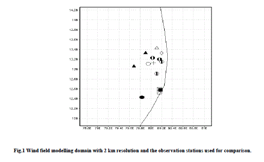
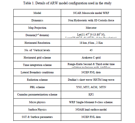
| The model is designed with three nested grids (18, 6 and 2 km) and with 45 vertical levels. The outer domain (domain 1) covered the Central Indian Peninsula to capture the largescale dynamics that might influence the circulations in the region of interest, the middle domain (domain 2) covered the south Indian region and the inner fine domain (domain 3) covered the Kalpakkam region. The 186 km grid (100 by 100 points) is centered at 12.8 N, 81.5 E and the finest 2 km grid (100 by 100 points) is centered at N, E and covers the Kalpakkam Coast (Fig.1). The second and third nests are two way interactive. The model physics options used are Kain-Fritsch scheme (Kain and Fritsch, 1993 and 2004) for convective parameterization, WRF Single Moment Class 3 (WSM3) simple ice scheme for explicit moisture (Hong et al., 2004), NOAH land surface model (Chen and Dudia, 2001), Dudhia scheme for short wave radiation (Dudhia, 1989) and the Rapid Radiative Transfer Model (Mlawer et al., 1997) for long-wave radiation processes. The USGS topography and vegetation data (25 categories) and FAO Soils data (17 categories) with resolutions 5m, 2m and 30sec (0.925 km) were used to define the lower boundary conditions. The model is initialized at 00 UTC and integrated for 48 hours for the simulations starting on 14, 16, 18, 20 , 22 September 2010 using the 1x1 degree 6 hourly National Centres for Environmental Prediction (NCEP) Final Analysis (FNL) data for initial and boundary conditions. |
II(D).Sensitivity Experiments |
| The land surface and PBL parameterizations influence the simulation of winds, turbulence, and other state variables in the lower atmosphere. To test the model sensitivity to PBL turbulence three conceptually different schemes namely Mellor-Yamada-Nakanishi (MYN) (Yonsei University (YSU) (Hong et al .2006), and Asymmetric Convective Model (ACM2) (Pleim, 2007) were selected. The YSU scheme (Hong et al 2006) is a non-local first order diffusion scheme and uses an explicit treatment of entrainment rather than implicit. The vertical transfers of various quantities are dependent on the bulk characteristics of the PBL and include counter gradient transports of temperature, momentum arising from large-scale eddies. The eddy diffusivity coefficient for momentum is a function of the friction velocity and the PBL height, while those for temperature and moisture are computed using a Prandtl number relationship. An entrainment layer is explicitly calculated in the PBL top proportional to the surface buoyancy flux. The MYJ and MYN schemes include a prognostic equation for turbulent kinetic energy (TKE), a level 2.5 turbulence closure approximation to determine eddy transfer coefficients and uses local vertical mixing within PBL (Janjic, 2001). The ACM is a highresolution eddy diffusion model, computes eddy diffusion in the stable and unstable conditions, both local and nonlocal transport in unstable conditions and is well suited for consistent PBL transports of various quantities. The friction velocity and the surface exchange coefficients for heat, moisture and momentum are calculated through the surface layer similarity theory for the YSU schemes. The land-surface models (LSMs) influence the eddy heat and moisture transports in PBL through the surface energy fluxes. The the NOAH land surface model (Chen and Dudhia, 2001) is used for calculating the time varying surface boundary fluxes with inclusion of explicit soil and vegetation effects. A set of 4 numerical experiments are conducted with different alternative PBL combinations (YSU, MY, MYN, ACM) (Table 1). The sensitivity experiments are conducted for 21-23 September 2010 with different PBL schemes. Subsequently 5 simulations were conducted for 14-25 September 2010 to evaluate the mean performance of the model |
II(E). Model evaluation methodology |
| Special field experiments were conducted between the meteorological observations used for model evaluations include the RRE experimental data sets between 12-25 September 2011 on GPS sonde vertical profiles, observations from three meteorological towers, 13 Automated Weather stations and fluxes from Sonic Anemometers. Model evaluations included both visual comparisons and statistical analysis. The region up to 850 hPa level (∼1.5 to 2 km above ground) is important as it covers the lower turbulent region in the atmosphere where vertical mixing and dilution of the pollutants occurs. Hence the surface and pressure levels 1000 hPa, 925 hPa, and 850 hPa are selected to assess the model performance. The comparisons from WRF outputs at the surface level are made for wind speed (WS10), wind direction (WD10) at 10m above ground, temperature (T2), and relative humidity (RH2) at 2m above ground. For upper air the outputs from WRF are compared at 925 hPa and 850 hPa levels for wind speed, wind direction, temperature and humidity respectively. The model results extracted from the nearest grid points to observation locations are used for comparisons. The error statistics is obtained through Pearson correlation coefficient (r), Mean Bias (MB), Mean Absolute Error (MAE) and Root Mean Square Error (RMSE). |
III. RESULTS AND DISCUSSION |
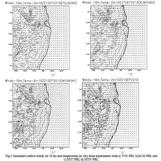
| Simulated surface level wind and air temperature distributions from experiments using four different PBL schemes are presented in Fig.2. It is seen that all the four schemes bring out the major features of the coastal circulations consisting of sea-land breeze and the convective boundary layer. The land-water air temperature gradient seems to be less by 1 degree celsius in the simulation with YSU as compared with other schemes. Spatial air temperature distribution indicates development of localized small scale convective cells or rolls which are simulated more predominantly in the cases MYJ and MYN. Such convective cells are expected to influence the dispersion and plume trajectory resulting in pockets of high or low concentration zones. As noted earlier, the spatial wind field is simulated stronger with the MYJ relative to both MYN and YSU. All the four simulations reveal off-shore winds in the morning and development of onshore winds in the daytime. The onshore winds are due to onset of sea breeze circulation at about 11 IST in all the PBL cases. However, the strength and inland progression of sea breeze is slightly different in the four simulations. These differences in simulated sea breeze characteristics have resulted in spatial differences in the wind field. Such wind field differences lead to variations in the plume dispersion, ground level concentration distributions among the four PBL experiments. The MYJ scheme produced stronger circulations as compared to YSU and ACM. |
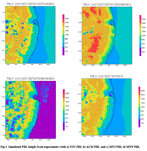
| Simulated PBL heights (Fig.3) are slightly higher with the convective PBL model (ACM) relative to the other three PBL cases. Also relatively deep boundary layers are seen to form with ACM, MYN schemes as compared to YSU and MYJ. Both MYJ, MYN schemes tend to produce spatially complex PBL patterns and indicates generation of more convective turbulence (Fig.15.2) than the other schemes. A prominent result from all four simulations is the development of relatively shallow mixed layers towards the coastal lands and deeper boundary layers inland. The shallow boundary layer is an internal boundary layer formed due to incursion of sea breeze and the differences in the humidity, temperature characteristics of the inland versus coastal air mass. The spatial differences in the mixed layer across the coast would lead to differences in effective volumes of mixing and hence differences in dilution, concentration of pollutants. |
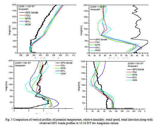
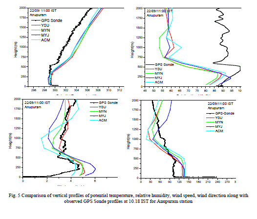
| To evaluate the relative performance of different PBL schemes for wind field simulations results are compared with experimental data sets of vertical profiles and hourly surface level meteorological observations. ARW simulated vertical profiles for temperature, Relative Humidity, wind speed and wind direction are compared against the GPS Sonde profiles on 22 September 2010 at 5:30 IST, 10:30 IST corresponding to the morning and daytime conditions are shown in Figs.4-5. The model simulations for 6 IST 22 Sep’10 (Fig.4) indicate highly stable conditions with steep inversion condition in the lower 250 m layer, characterized with increase in temperature, decrease in humidity and increase in wind speeds. Though these features are produced in all the simulations, YSU has given a better comparison with observations than other schemes. The profiles given by various experiments widely differed with height for wind speed and direction, with closer comparisons using the experiment YSU. In the morning conditions, the wind speed is noted to be higher with all the PBL schemes though YSU has given nearest values. Comparison of various profiles in the daytime show well mixed convective layers up to 600 m height with a capping inversion above that. The winds are well produced by YSU and MYN. However all the schemes failed to represent the wind directional shear during the stable conditions in the lower 500 m region of the atmosphere. Profiles of wind speed and wind direction from different simulations though follow a trend; they widely deviate in the lower atmosphere. The YSU PBL diffusion scheme produced the nearest wind speed and wind direction profile. The humidity comparison for this time is not good due to a snag in humidity sensor and hence not shown. |
| The vertical profiles from simulations during the daytime (Fig.5) indicate convective well mixed conditions in the lower 400 m layer with a capping inversion aloft indicating the mixed layer depth of 400 m during daytime. The simulated potential temperature profiles in all PBL cases agrees with GPS sonde observed profile but with a slight underestimation of mixed layer height. The simulations show underestimation in daytime humidity, overestimation in wind speed, slight underestimation in potential temperature. MYJ gives higher winds and both ACM, MYN give lower winds. The vertical trends of various parameters are well represented by the model except the wind direction. Large direction differences (~30 to 60 deg) are noted in wind in the lower levels and YSU, ACM seem to produce the nearest trends. Of the four tested PBL schemes the YSU scheme is found to provide reasonable comparisons in the boundary layer. |
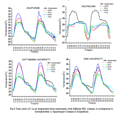
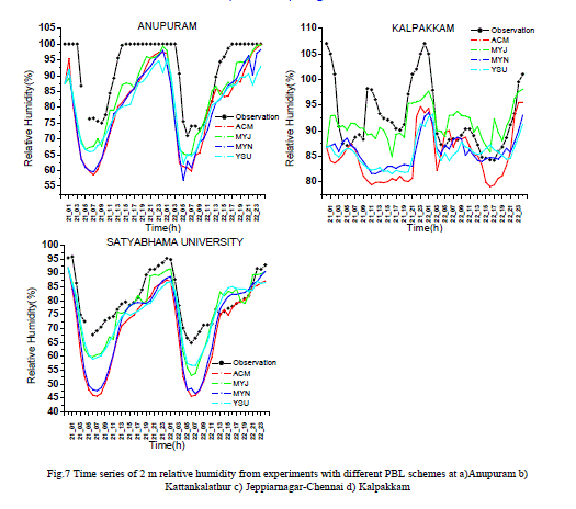
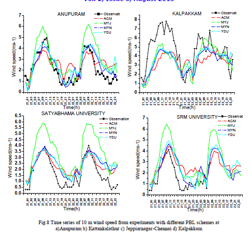
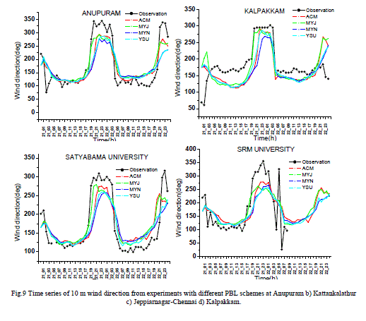
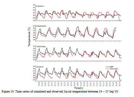
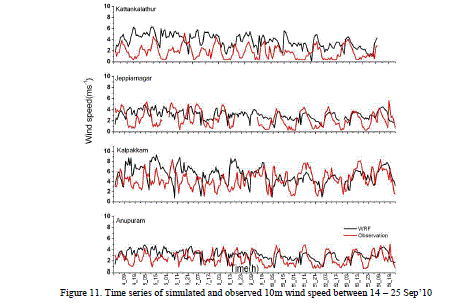
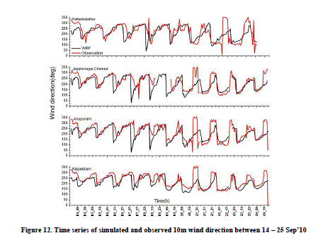
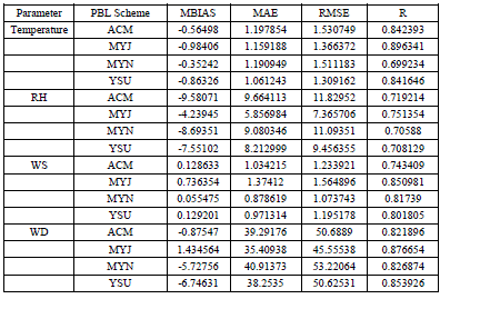
| The diurnal evolution of various surface atmospheric parameters determines the diurnal plume trajectory variations and needs to be accounted realistically. Time series of 2 m air temperature, relative humidity, wind speed and wind direction at four stations Anupuram, Jeppiarnagar, Kattankalathur and Kalpakkam are presented in Figs.6-9. Kalpakkam is just at the coast, Anupuram is 6 km inland, the remaining two (Kattankalathur, Jeppiarnagar) are about 25 km inland. The amplitude of diurnal temperature variation is well-defined at the inland stations as compared to the coastal stations. This trend could be represented by the model. Both MYN and ACM have a warm bias in the day time temperature while MYJ and YSU have slight cold bias in the daytime as well as night time temperature. All the PBL schemes indicate dry bias and MYJ, YSU give closer comparisons. For wind speed MYJ gives overestimation throughout the diurnal cycle. The other three schemes ACM, MYN and YSU give overestimation in the night time. The YSU gives nearest comparison for wind speed. At the coast of Kalpakkam the model underestimated the wind speed with all the PBL schemes. The model with a resolution of 2 km may not resolve the land-water difference (sub-grid variability) at the coast. Wind direction is very aptly simulated by the model at all the four stations with all the PBL schemes (Fig.9). Four error metrics [BIAS, Mean Absolute Error (MAE), RMSE (Root Mean Square Error), and Correlation are estimated between simulation and observations for 2 m temperature (T), relative humidity (RH), wind speed (WS) and wind direction (WD) at 16 observation locations in the mesoscale fine domain (Fig.1). It is seen that all schemes give a warm bias (ie., observation – model <0) in temperature. The YSU has least errors (MAE, RMSE) and reasonably good correlation for temperature (r=0.84). For humidity both MYJ and YSU give less errors and good correlations. For wind speed the YSU, MYN have less errors and reasonably good correlations. For wind direction the YSU has least errors followed by MYJ, ACM and MYN schemes. Thus the sensitivity tests indicate that YSU gives a more realistic diurnal cycle of various surface layer parameters with better error statistics than the other three schemes MYJ, MYN and ACM. The differences in the simulations with different PBL schemes is because of the variation in parameterization of turbulence exchange coefficient and the way surface fluxes delivered by the surface layer schemes (Hu et al., 2010). The eddy diffusivity coefficient is determined from turbulence kinetic energy (TKE) and a length scale in MYJ, MYN schemes and from friction velocity and PBL height in YSU and ACM schemes. A total of six simulations are performed for the period 14-25 2010 with the identified best scheme for PBL i.e., YSU to study the model wind field during the RRE experiment phase-I period. The time series of surface meteorological parameters from the four schemes are presented in Figs 10-12 for four stations Kalpakkam, Anupuram, Jeppiarnagar and Kattankalathur along with surface meteorological parameters. It is seen that the model reproduces the trends in surface temperature, humidity, and winds in reasonably good comparison with observations at most places. Temperature is slightly overestimated (warm bias) and with mean absolute error of 1.2 0C. Slightly stronger winds are simulated with mean absolute errors of 1.75 ms-1. The simulated winds are overestimated by 15%. Overestimation of winds has been reported to be a common problem in several studies (e.g., Steenveld et al., 2008). Wind direction is very precisely simulated with mean errors of 25 deg. |
IV.SUMMARY AND CONCLUSION |
| Accurate simulation of wind flow field is highly challenging in complex coastal terrain as many models fail to capture the mesoscale terrain induced phenomena due to insufficient resolution and appropriate physics. The present study applied a high resolution non-hydrostatic mesoscale model ARW for flow field simulation at Kalpakkam tropical coastal site. Observations collected from special field experiments were used in the model validation. The model could simulate the sea-land breeze circulation during the summer southwesterly synoptic flow condition (i.e., under opposing large scale wind) as well as the spatial variations in the wind field and boundary layer height. Simulations with various PBL physics options clearly demonstrate that the MYJ, MYN, ACM have given stronger winds, deeper boundary layers and with warmer temperatures and dry environmental conditions relative to YSU scheme. Comparisons with 16 surface station data and 1 GPS sonde data revealed that various simulated meteorological quantities compared well for the YSU non-local diffusion scheme. Though most PBL schemes produced the diurnal cycle of various parameters the YSU is found to give good consistency in terms of both diurnal variation and magnitudes. Simulations for the 10 day period in 14-25 Sep’10 indicate the model reproduces the trends in surface temperature, humidity, and winds in reasonably good comparison with observations at most places. Overall, the model produced slightly warmer temperatures (MAE=1.2 C), slightly stronger winds (MAE= 1.75 ms-1) and overestimated by 15%. These simulations are reasonably good for air pollution dispersion application. The results are expected to be improved with enhancement of initial conditions by assimilation of available meteorological data. A few aspects like timing of the sea breeze circulation, the convective cells development and the associated changes in the boundary layer need special attention, which will be attempted in future studies. |
ACKNOWLEDGEMENT |
| This research was performed under the Research Grant on “Round Robin Exercise for Atmospheric Flow field Modelling” by Board of Research in Nuclear Sciences in collaboration with Indira Gandhi Centre for Atomic Research, Kalpakkam. Special thanks are due to the IGCAR, Kalpakkam for providing the field meteorological observations used in the study. |
 |
| ` |
 |
 |
 |
 |
 |
 |
 |
 |
 |
 |
 |
 |
 |
References |
|