ISSN ONLINE(2319-8753)PRINT(2347-6710)
ISSN ONLINE(2319-8753)PRINT(2347-6710)
M.Sedhuraman1, S.S.Revathy2, S.Suresh Babu3
|
| Related article at Pubmed, Scholar Google |
Visit for more related articles at International Journal of Innovative Research in Science, Engineering and Technology
Groundwater plays a fundamental role in shaping the economic and social health of many urban areas in India. Fast growing and emerging urban centres are demanding water to achieve higher growth rates. The exploration, assessment and management of ground water resource has become one of the key issues as ground water forms an important component of the total water supply for drinking and irrigation purposes. The present study area is an attempt to delineate the groundwater potential zones in Bengaluru urban district, Karnataka, India using integrated approach of Remote Sensing and GIS techniques. Various geological and geomorphological factors play a major role at different levels in the occurrence, movement and potential of ground water in hard rock terrain. Survey of India (SOI) Topographic maps and Resourcesat-2 (LISS IV FMX) satellite image are used to prepare various thematic layers such as geology, geomorphology, drainage pattern, lineaments, soil and slope, which influence the occurrence, movement, yield and quality of groundwater. All these themes and their individual features were then assigned weights according to their relative importance in groundwater occurrence. The thematic layers will be integrated using ERDAS and Arc GIS software to identifying the overlay analysis & yield of the ground water potential zone map of the study area. On the basis of different geomorphic units, four categories of groundwater potential zones were delineated as (i) Good (ii) Moderate (iii) Poor and (iv) Very poor.
Keywords |
| Geology, Geomorphology, Resourcesat-2 (LISS IV), Remote Sensing and GIS. |
INTRODUCTION |
| Groundwater is an essential component of the environment and economy. It sustains the flow in our rivers and plays an important role in maintaining the fragile ecosystems. Ground water contributes to about eighty percent of the drinking water requirements in the rural areas, fifty percent of the urban water requirements and more than fifty percent of the irrigation requirements of the nation. Bangalore is the sixth largest city of India and one of the fastest growing cities of Asia. It has acquired the name of „Silicon CityâÃâ¬ÃŸ, due to its progressive trend in Information technology. Now, after the IT boom, Bengaluru city has suddenly overgrown its size and the district administration is facing a challenging task for providing necessary infrastructures to the related economic activities, trade, commerce and housing facilities. Especially, the enormous pressure on water particularly ground water in the district needs scientific planning and effective management of water resources (CGWB, Bengaluru 2013). The proper management of both surface and groundwater resources through systematic inventory, conservation and proper planning is essential for economic and social development of any country. The groundwater prospecting especially in hard rock terrains requires thorough understanding of geology, geomorphology and lineaments of an area, which are directly or indirectly controlled by the terrain characteristics like weathering grade, fracture extent, permeability, slope, drainage pattern, landforms, land use/land cover and climate (Jaiswal et al 2003, Yeh et al. 2008, Ravindran &Jayaram 1997, Lokesh et al. 2005). |
| In hard rock terrains, availability of groundwater is of limited extent. Occurrence of groundwater in such rocks is essentially confined to fractured and weathered horizons (Uday Kumar& Binay Kumar 2010). Hence, remote sensing is useful in the search for groundwater prospect zones as it provides the current spatial disposition of basic information on geology, landforms, soils, land use/land cover, surface water bodies, etc. quickly and reliably with less cost and manpower than conventional techniques. Satellite data of the EarthâÃâ¬ÃŸs surface obtained by remote sensing provides a first-hand tool (Drury 1986) in illustrating conditions as they exist at a particular time in a given area and helping in demarcating surface and sub-surface expressions related to hydromorphology, tectonics (lineament, fracture, joints, faults), land use, land cover, etc., which are indicative of groundwater movement and localization (Krishnamurthy et al. 1992). In addition, quantitative morphometric parameters of the drainage basin also play a major role in evaluating the hydrological parameters, which in turn helps to understand the groundwater situation (Krishnamurthy and Srinivas 1995). |
| The main Objectives of this Project: |
| To prepare thematic maps on surface and subsurface features. |
| To assign weightage for each theme and individual features of each theme. |
| To integrate all thematic maps using overlay analysis tool in ArcGIS and demarcating Groundwater Potential Zones of the study area. |
STUDY AREA |
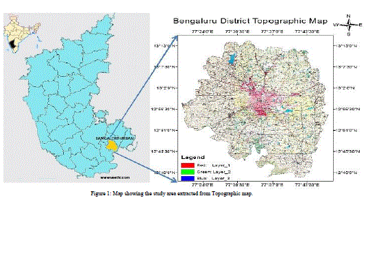
| The study area (Bengaluru Urban District)is located in the southeastern part of Karnataka shown in figure 1. It is having an aerial extent of 2190 sq.km and is located between the North latitude 12º39âÃâ¬ÃŸ32” to 13º14âÃâ¬ÃŸ13” and East longitude 77º19âÃâ¬ÃŸ44” to 77º50âÃâ¬ÃŸ13”. The major rivers of the area are Shimsa, Kanva, Arkavathi, South Pennar and Vrishabharathi. Shimsha and Kanvariver of the Cauvery basin is draining majority of the district and Anekal taluk is drained by South Pennar river of Ponnaiyar basin. Total population of this district is 95,88,910. The mean annual rainfall for Bengaluru is 1049mm. |
 |
MATERIALS AND METHODOLOGY |
A. Materials Used: |
| Survey of India topographic maps (SOI) of 2007 edition(1:50,000 scale) and Indian Remote Sensing (IRS-P6) ResourceSAT2 Linear Self Scanning (LISS-IV, 5.8 m resolution) images of 2012 were employed in this study to prepare various thematic maps of the study area. The SOI topographic maps and satellite images have been geometrically corrected using ERDAS v9.1and ArcGIS v10.0software.Geology map of the basin was prepared using Geological Survey of India (GSI) in the scale of 1:2,50,000 whereas the soil map was prepared using the satellite imagery and National Bureau of Soil Survey (NBSS). |
| B. Methodology Used: |
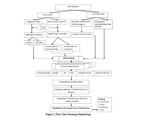
| Methodology for the investigation and study is summarized in flow chart (Figure 2). It involves the following process |
| Data collection and review of previous work |
| Thematic Maps Derivation |
| Maps Analysis and Interpretation using GIS |
| Identification of Ground Water Potential Zones. |
 |
RESULTS AND DISCUSSION |
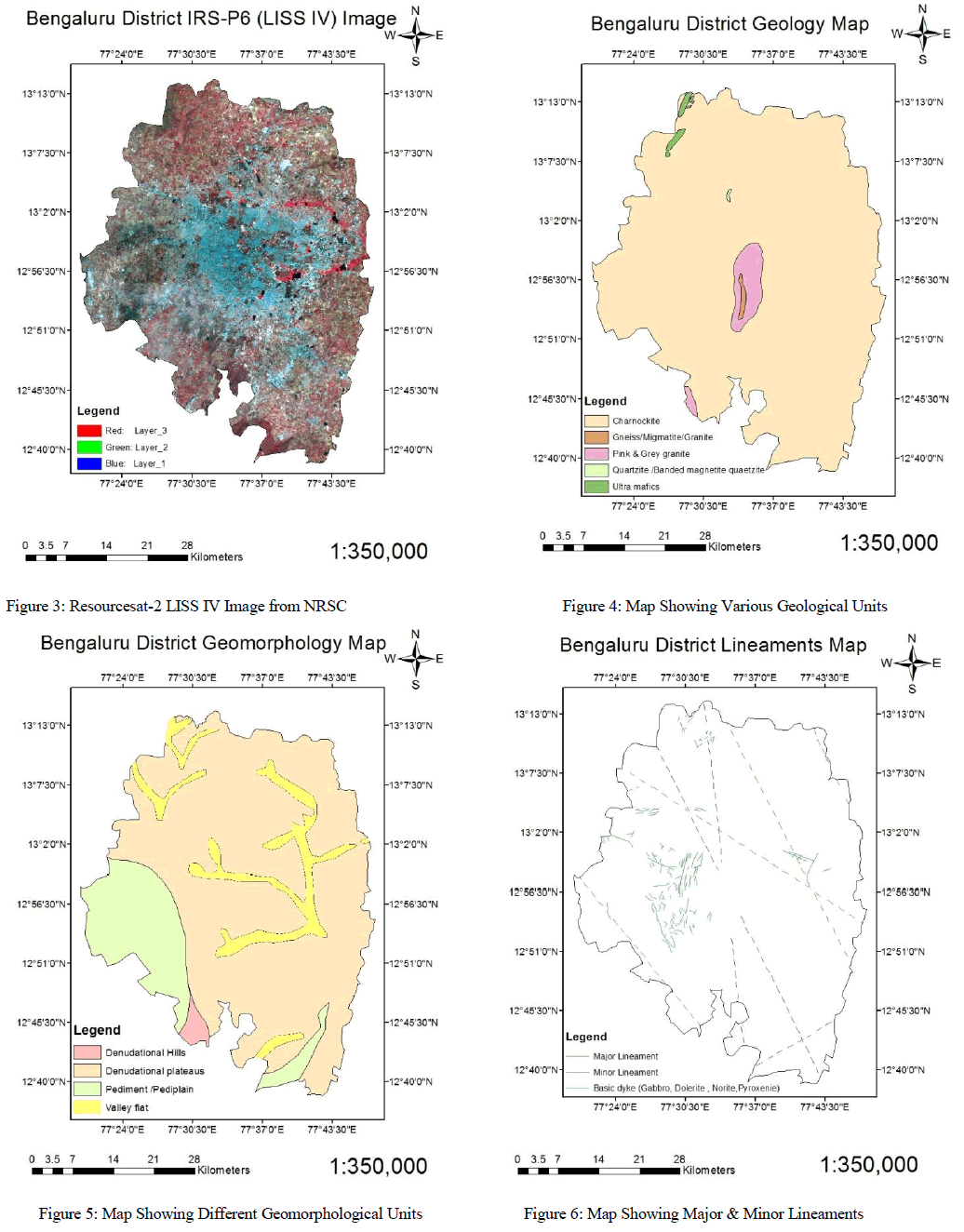
| Integration of various geological and geomorphological parameters based on the various thematic maps such as geomorphology, geology, lineaments, slope and soil, the groundwater potential zone map have been mapped. In order to understand the various hydromorphogeological units of the study area, the thematic maps has been prepared with the help of Resourcesat-2 (IRS-P6) LISS-IV high resolution satellite imagery is shown in Figure 3. |
| A. Geology: |
| As the study area is densely covered by buildings, it is very difficult to obtain the detailed geological map. A general geological map of Bangalore urban district is prepared based on the available maps of Geological Survey of India (GSI) and presented in Figure 4 for the study area. Bengaluru lies on top of the south Karnataka Plateau (Mysore Plateau) and its topology is almost flat with the highest point being at Doddabettahalli (954 m above Mean Sea Level) in the direction of a NNE-SSW trending ridge lies east of the Vrishabhavathi river. The study area falls under the expanse of the Peninsular Gneissic Complex. The main rock types in the regions are Gneissic country rock and as well as intrusions of Granites and Migmatites. Bangalore district lies over a hard and moderately dense Gneissic basement dated back to the Archean era (2500-3500mya).They recorded the principal rock formations namely upper vindhyan super group, deccan traps and inter trappean beds, andalluvium and laterite. These rocks types represent different time segments within Archean era. |
| Granites and Gneisses of peninsular gneissic group constitute major aquifers in the urban district of Bangalore. Laterites of Tertiary age occur as isolated patches capping crystalline rocks in Bangalore north taluk and ground water occur in phreatic condition. Alluvium of limited thickness and aerial extent of 20 to 25m thick occur along the river courses possessing substantial ground water potential. Ground water occurs in phreatic conditions or unconfined conditions in the weathered zone and under semi confined to confined conditions in fractured and jointed rock formations. The occurrence of Ground water movement and recharge to aquifers are controlled by various factors like fracture pattern, degree of weathering, geomorphological setup and amount of rainfall received. Generally the depth of weathering varies, being more in the valley, and often extending up to 30 m in the dug wells. However the yield in the bore well is dependent upon factors like degree of weathering, presence of joints and fractures and its connectivity and the presence of intrusive bodies. |
B. Geomorphology: |
| Four important erosional and depositional geomorphicunits such as denudational hills, denudational plateau, pediment/pediplain and valley fillsare mapped and shown in Figure 5. |
| 1) Denudational Hills: |
| Denudational hills are the remnants of the natural dynamic process of denudation and weathering. The geomorphic forms of denudational hills occur as exfoliation domes, linear ridges, mesas, low mounds and tors with partial scree or debris covered at the foot slopes. The geomorphic expression and shape of the denudational hills are controlled by lithology, and spacing of structural features like joints and fractures occurring in them. The denudational hills in basic intrusive occur as narrow linear ridges within the pediplain where dykes are seen. Denudational hills with an average height of 700 m above mean sea level occupy the southwestern part of the study area. They are exposed as a group of massive hills with resistant rock bodies and rounded summits and are formed due to differential erosion and weathering. Denudational hills are identified in the satellite imagery by their massive size and domes to elliptical shape. They appear as dark green in color in the satellite imagery. These hills are covered with big boulders and sparse vegetation in contrast to structural hills. This landform acts as a high runoff zone due to its deep slope. Denudational hills due to their relief acts as watershed boundary. The total coverage of this unit is 22.625 km2 and it occupies 1.054 % of the study area. The groundwater potential of this landform is very poor. |
| 2) Denudational Plateaus: |
| Denudational Plateaus can be formed by a number of processes, including upwelling of volcanic magma, extrusion of lava, and erosion by water and glaciers. Magma rises from the mantle causing the ground to swell upward, in this way large, flat areas of rock are uplifted. Plateaus can also be built up by lava spreading outward from cracks and weak areas in the crust. Plateaus can also be formed by the erosional processes of glaciers on mountain ranges, leaving them sitting between the mountain ranges. Water can also erode mountains and other landforms down into plateaus. This landscape unit is dominant in the major part of the study area. The land of this unit is severely dissected by the streams of Akoli watershed giving size to a terrain consisting of flat-topped ridges and steep scarps. This unit has evaluation range of 450 to 500 m above msl and occupies 34.6% of the total area. |
| 3) Pediment / Pediplain: |
| The term 'pedimentâÃâ¬ÃŸ is defined, as an eroded rock surface of considerable extent at the foot of a mountain slope or a face formed under arid to semi-arid climate erosion. The pediments have very thin cover of soil, but its thickness may increase away from the pediment junction. The pediment overlies all the lithological units with gentle to moderate slopes and is generally characterized by rugged appearance with number of small outcrops and supports scanty vegetation. Sheet erosion and gullying are very active in the zone of pediment exposing the underlying weathered mantle of bedrock at number of places. It usually meets the hill slope at an angular neck line, and may be covered by transported material. The low moisture content of this unit gives a bright signature in the satellite imagery, especially around the hills. Pediment follows steep slopes in the study area and is considered as the most suitable hydrogeomorphic class because it checks the velocity of surface runoff and thus provides more chance of water accumulation. |
| A Pediplain is developed by a combination of process including stream erosion, weathering, sheet wash and lateral plantation. The pediplains are formed as a result of weathering under arid and semi-arid conditions, representing the end stage of cyclic erosion (King, 1950; Sparks, 1960). When the sediment developed over a large area as a result of continuous process of pedimentation, it is normally termed as a pediplain (Agarwal and Garg, 2000). The pediplains are characterized by the presence of relatively thicker weathered material. The extent and thickness of weathering depends on the slope, resistance of the underlying rock to weathering, presence of joints and fractures and precipitation and climatic conditions of the area. Depending upon the thickness of the weathered zone, the groundwater potential is moderate to good and eligible for construction of a well. This unit is scattered around the study area and its coverage is 327.225km2 and it occupies 15.238% of the study area. Overall groundwater prospect is good in this unit. |
| 4) Valley Flats: |
| Valley flats are low linear areas occurring between hills. These units occupy the lowest reaches in topography with nearly level slope. The valley flat deposits are colluvium fluvialin origin derived from weathering and deposited by the action of streams at the floor of valleys. Depending upon the parent rock, the valley fills deposits vary in composition and texture (Agarwal and Garg, 2000). Normally, they are covered with red, brown and black coarse gravel to sandy and clayey soils. In the study area, the valley fills are identified between the structural hills on the northern part of the study area. The drainage pattern over the valley fills is parallel to sub-parallel indicating that the drainage is by and large controlled by the lineaments. They exhibit dark reddish tone and medium texture in the satellite imagery, which indicates high moisture content due to intensive cultivation. This unit occupies in upper northern part of the study area and it covers 189.996 km2 areas and occupies 8.846 % of the study area. Groundwater prospects in valley fills are good to excellent because of the topographical location at the bottom of the hill and geological composition consisting of highly porous materials. Subsurface water potential is also good to excellent in the valley fills (Murthy and Rao, 1999). |
| C. Lineaments: |
| Lineaments(Figure 6) are the linear features of tectonic origin then are identified as long narrow and relatively straight tonal alignments visible in satellite images. A lineament may by a fault, fracture, master joint, a long and linear geological formation, the straight course of streams ,vegetation served may be the result of faulting and fracturing and hence it is inferred that they are the areas and zones of increased porosity and permeability in hard rock areas. These have more significance in the ground water studies. Remote sensing data provides useful information to identify structural features and lineaments. The satellite data of Resourcesat-2 LISS IV Imageries of false color composite have been visually interpreted to identify the lineaments of the basin area. The data have been checked by field studies and Survey of India topographical maps at the1:50,000 scale. The interpretation of satellite data indicates that the rocks appear to have been deformed repeatedly. |
| D. Drainage Density: |
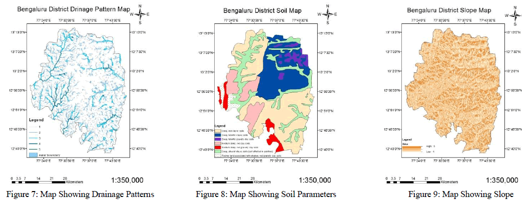
| The drainage density is an inverse function of permeability. The less permeable a rock is, the less the infiltration of rain fall, which conversely tends to be concentrated in surface runoff. This gives rise to a well-developed and fine drainage system. Since the drainage density can indirectly indicate the suitability for groundwater recharge of an area because of its relation with surface runoff and permeability, it was considered as one of the indicators of groundwater potential.The drainage density map shows(figure 7) the flow of water throughout the study area. Drainage density is defined as total stream length per area.More the density high would be the runoff. Drainage Density it is group in to 3 classes:0-1.0 km; 1.0-2.0 km; 2.0-3.0 km. The suitability of groundwater potential zones is indirectly related to drainage density because of its relation with surface runoff and permeability. |
| D. Soil: |
| Soil is an important factor for delineating the groundwater potential zones. The analysis of the soil type reveals that the study area (figure 8) is predominantly covered by Red loamy and sandy soils, Laterite soil.Red loamy and sandy soils generally occur on hilly to undulating land slope on granite and gneissic terrain. It is mainly seen in the eastern and southern parts of Bangalore north and south taluks. Laterite soils occur on undulating terrain forming plain to gently sloping topography of peninsular gneissic region. It is mainly covered in Anekal taluk and western parts of Bangalore North and south taluks. |
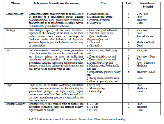
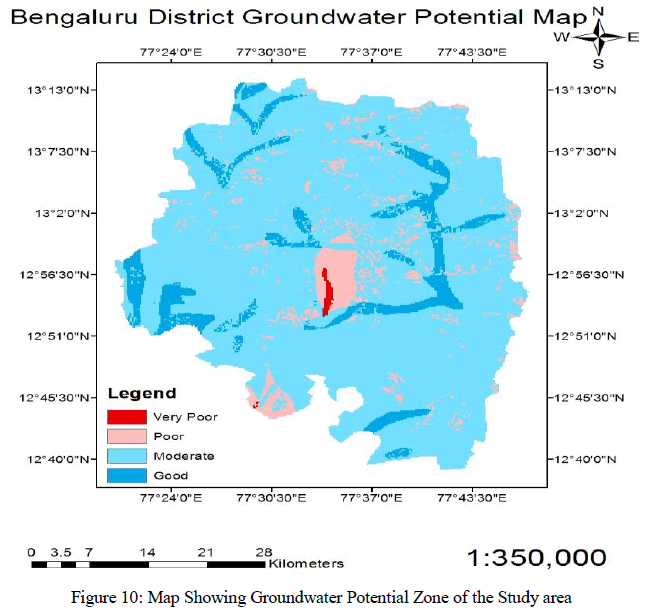
| The good prospective zones are along thevalley flat, pediplains, charnockite, ultramafics,major lineaments and weathered zones. The major portion of the study area falls under moderate prospective zones. The poor prospective zone falls under denudational hills and Granite Gneiss are the region where more withdrawal of water takes place for domestic and industrial purposes.Thus, the total amount of average annually exploitable ground water reserve is more for the moderate zone compared to the good zone, which is attributable to the larger area under the moderate zone. Therefore, these groundwater reserves can be considered as sustainable yields of the respective zones, which can be safely utilized to meet the water demands of different sectors in the study area. The occurrenceand movement of groundwater depend upon the formation of rocks present in study area. It also depends upon the topography, geomorphology & structure as well as hydro-geological properties of the water-bearing materials.Groundwater prospect of all the hydrological features and their ranking are given in Table 1 |
 |
 |
 |
GIS ANALYSIS |
| The thematic maps derived through the interpretation of satellite data i.e., geology, geomorphology, lineament, drainage patterns and soil were digitized, edited and saved as shape files in GIS software. The lineament and drainage maps were digitized as line coverage whereas geological and geomorphological maps were digitized and saved as polygon coverage, assigning unique polygon to each geological /geomorphological unit. The maps were then projected to a common UTM projection system so as to subsequently superimpose in ArcGIS using to weighted overlay sub-module to demarcate groundwater prospect zones based on above themes. Integration of thematic maps led to the demarcation of groundwater potential map which qualitatively defines the prospect zones for future groundwater development in and around Bengaluru urban district. Thus, the groundwater prospective zones are obtained for the study area was represented in the figure 10. |
 |
CONCLUSION |
| The study area reveal that utility of Remote sensing and GIS technique in delineating groundwater potential zones in highly variable terrains representing various geomorphic features/landforms. Remote sensing data (Resourcesat-2 LISS-IV), topographic maps and conventional data were used to prepare the thematic layers of geology, geomorphology, lineaments, drainage density, soil and slope. The thematic layers were then integrated in the GIS environment to prepare a groundwater potential zone map of the study area. The geomorphological features of these areas provide a simple and efficient way to identify the groundwater potential zones and to contribute to the decisionmaking process. On the basis of different geomorphicunits, there are four categories of groundwater potential zones were delineated as (i) very poor (ii) poor (iii) moderate and (iv)good. Groundwater potential is more promising in the valley flat, which is associated with thick alluvium and weathered material due to high porosity and permeability. The valley flats are good favorable zones for groundwater which are limited in the study area. Weathered pediplains and ultramafics are distributed all along the river course indicating low permeability characteristics and they can be classified as moderate groundwater potential zones. The geomorphological units likedenudational hills and denudational plateaus are classified as poor groundwater potential due to high surface runoffs. The geological units like Gneiss/Migmatite/Granite are considered very poor ground water potential zones whereas charnockite is considered as good groundwater potential zone. |
References |
|