ISSN ONLINE(2319-8753)PRINT(2347-6710)
ISSN ONLINE(2319-8753)PRINT(2347-6710)
Jitender Kumar Nagar1, Dr. Anita Singhrova2
|
| Related article at Pubmed, Scholar Google |
Visit for more related articles at International Journal of Innovative Research in Science, Engineering and Technology
Vehicular Ad hoc Networks is an emerging technology. In Vehicular safety algorithm, the source vehicle that detects an accident can generate a warning message and propagate it to the succeeding vehicles to notify drivers before they reach to the potential danger zone on the road. The main application of VANET is in Intelligent Transportation System providing various applications such safety and non-safety related services. VANET is subclass of Mobile Ad hoc Network. Dynamic topology change and high speeds of nodes creates a distinction from MANET. In this paper we discuss the impact of traffic light employed at intersections on the routing process. This paper proposes an effective and reliable routing protocol that takes traffic lights into consideration
Keywords |
| ITS, GPSR, MANET, V2I, V2V, VANET |
I . INTRODUCTION |
| During the last few years vehicular communication is attracting growing attention from both academic and industrial point of view. This is because of its applications ranging from road safety to traffic control and up to infotainment. Vehicular ad-hoc networks (VANETs) are self organized networks built up from moving vehicles. VANETs are instantiation of Mobile Ad-hoc Networks (MANETs). As in MANETs, packet forwarding in VANET takes place through multi hop relaying. But certain features distinguish VANETs from MANETs. These include high mobility of nodes, frequent network partition, constraints on roadways, etc. These characteristics pose technical challenges to implement high performance Vehicular networks. Possible applications [1-2] can be generally classified as safety and non safety applications. |
| Safety applications include cooperative driving, accident avoidance etc. Non-safety applications include traffic information, toll service, internet access, games, entertainment etc. Success of VANET applications depends on how data is routed between nodes. The history of VANET routing protocols starts with MANET routing protocols such as Ad-hoc On Demand Distance Vector routing (AODV)[3] ,Dynamic Source Routing [4] etc. But these protocols fail to address certain peculiar characteristics of VANET. Then various routing protocols especially for VANET were proposed. |
| Designing a routing protocol for urban environment is quite challenging task since the traffic lights deployed at intersections divide the road in to different segments. The nodes move at constrained speeds through these segments. In such an environment intersection based routing protocols are highly reliable. In intersection based routing, when vehicles move on straight road, they forward by greedy forwarding. When they reach an intersection a decision is made whether to forward in same direction or to perpendicular direction. Many intersection based routing protocols have been proposed to carry efficient routing in VANET. But only few protocols consider traffic lights. |
| The communication in the VANET appears in such forms i.e. Intra-Vehicle (InV), Vehicle-to-Vehicle (V2V), and Vehicle-to-Infrastructure (V2I) communications[5]. This communication takes place with the help of communication protocol called Dedicated Short Range Communication protocol (DSRC) Automatic IP address configuration is unexplored issue in vehicular ad hoc network (VANET) environment [6-7]. |
| This paper proposes a new routing protocol by considering traffic lights. The new protocol proposes how data are routed on a straight road and what decision should be taken when data reaches intersection. The remaining of this paper is organized in to following sections: Section II gives related works, Section III describes the problem at intersection, Section IV describes Algorithm and their steps, Section V gives the simulation setup, Section VI gives Simulation Result, and Section VII gives conclusion and future scope. |
II RELATED WORK |
| VANET routing protocols can be categorized mainly in to two: topology based and geographic (position based) routing protocols. In topology based routing protocols each node is expected to know the entire network topology. In Geographic or position based routing protocols the decision on routing is based on the position of the sender, position of the destination and position of the sender’s one hop neighbours. It is assumed that each vehicle is employed with GPS and can know its own position and the position of its destination. The position of its one hop neighbours is obtained from periodically exchanged beacons. In geographic routing the messages can be forwarded to destination without knowing the topology and without prior route discovery. Geographic routing protocols are more Prominent among various routing protocols[2]. |
| In[8], a Greedy Perimeter Stateless Routing (GPSR) is proposed. In GPSR, a node forwards a packet to an immediate neighbour which is geographically closer to destination. When local optimum is reached a recovery mode is used to forward a packet to a node that is closer to destination than the node where the packet encountered local maximum. In[9], Vehicle Assisted Data Delivery (VADD) is proposed. VADD aims at improving routing in disconnected networks by using the idea of carry and forward together with Vehicular mobility prediction. |
| In[10], Shortest Path Based Traffic Aware Routing (STAR) is proposed. Shortest path based Traffic Aware Routing is an intersection based routing protocol proposed for urban areas where traffic density is high and intersections are deployed with traffic lights. In STAR protocol the data is forwarded using greedy forwarding together with carry and forward recovery mechanism. |
| In[11-12], Vehicle Assisted Data Delivery (VADD) is proposed. VADD aims at improving routing in disconnected networks by using the idea of carry and forward together with vehicular mobility prediction. In[13], an Improved Greedy Traffic Aware Routing (GyTAR) is proposed. GYTAR is an intersection based routing protocol consisting of 2 modules: dynamic junction selection through which a packet must reach destination and an improved greedy strategy used for forwarding. In GyTAR a forwarding node looks for the neighbouring junctions in digital map. Then it assigns a score to each of these junctions considering the traffic density and curve metric distance to destination. The junction with highest score is selected to forward the packet. Once junction is selected the next phase is to forward the packet between these junctions. |
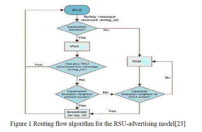
| In recent years, the interest in VANETs research has dramatically increased. The applications in vehicular safety have widely been discussed by the National Highway Traffic Safety Administration (NHTSA) [14-16]. For example, the Vehicle Safety Communications (VSC) Project brings BMW, DCRTNA, Ford, GM, Nissan, Toyota, and VW together to work cooperatively. The VSC Project identifies vehicle safety applications enabled by DSRC communications. Safety applications rely on broadcasting. There is some previous research that addresses the broadcast messaging in VANETs. In [17-19], for example, Tonguz et al. proposed a distributed vehicular broadcasting protocol (DV-CAST), which makes local routing decisions based on a vehicle’s connectivity. Farnoud et al. in [20-22] used a positive orthogonal code to distribute a transmission pattern for broadcast messages. |
 |
III PROBLEM AT INTERSECTION |
| In urban areas the intersections are employed with traffic lights. These traffic lights divide the road in to different red and green light segments. The vehicles move smoothly on a green light segment and when light turns to red they slow down and wait at intersections until the light turns green. Thus, the vehicles tend to cluster at both directions in a red light segment. This clustering of vehicles generates a gap between vehicles and thus creates a traffic hole problem. |
IV ALGORITHM |
| It is assumed that each vehicle is employed with GPS and digital map. Each node knows its position, position of its neighbours and position of destination. The traffic lights installed at the intersection of roads contains the transmitter and receiver which sends and receives data packets during the peak hours of traffic. |
| The algorithm works in two steps |
| (i) Straight Mode: In straight road, vehicles forward packets by greedy forwarding mechanism. If the destination is reachable, packet is forwarded to destination else the packet is forwarded through hop by hop mechanism or through the RSU. |
| (ii) Intersection Mode: In intersection mode, when a packet reaches an intersection it checks whether destination is connected if so, it will transmit the packet. The intersection is given priority over straight mode. Thus the packets always stay on connected links and ensure highly efficient routing. |
Steps: |
| Step 1. Create n no. of mobile nodes from MN1,MN2,.........,MNn which which are moving on the road. for(i=1;i<=n;i++) |
| Step 2. Create n no. RSU starting from RSU1,......,RSUn for(i=1;i<=n;i++) |
| RSU no. i= RSU[i]; |
| Step 3. Create m no. of cluster slots, C[i] denote the ith cluster head. for(i=1;i<=m;i++) |
| { |
| cluster head i= C[i]; |
| } |
| if(distance between MN[1] and MN[2] is less than Range) |
| { |
| then MN[1] and MN[2] are in same cluster i.e. C[i]; |
| } |
| else |
| MN[1] is in cluster C[i] and MN[2] is in cluster C[j]; |
| Step 4. Repeat step 5 to 10 for broadcasting data packets |
| Step 5. Let S be the source and H be the broadcasting host |
| and Dmin be the distance between the source and broadcasting host |
| if(Dmin < D) |
| then wait for random no. of slots; |
| then submit message for retransmission to start; |
| else |
| retransmit the message. |
| Step 6. if (there is change in the node density) |
| (a) then recalculate the transmission range; |
| (b) Recalculate the routes between the different intersections and the RSU |
| (d) Send this message to the nodes in the network |
| end; |
| Step 7. If (the MN is at intersection) then |
| send the data packets to traffic lights for transmission |
| and go to step 8 |
| else go to step 8 |
| Step 8. if a MN has to transmit data then |
| (a) Queries its neighbours about the optimal backbone route before message forwarding |
| (b) if the information is available then |
| Step 9. (a) optimal route information is sent to source node |
| else |
| (b) query is relayed to RSU and receive the information from RSU |
| end; |
| Step 10. On Receiving the response of query |
| (a) Save the updated route information; |
| (b) Adjust the transmission range; |
| Step 11. (a) use this information to send the data packets to the destination. |
| (b) send the data packet |
| end; |
V SIMULATION SETUP |
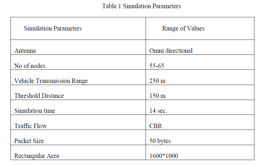
| In this section the performance of Proposed Algorithm is evaluated using NS2 [24]. The Vehicles moves at maximum speed of 60-65 Kmph and move at minimum speed of 20-25 Kmph. The acceleration and de-acceleration speeds are 1.5 m/s and 1.5 m/s respectively. The threshold distance is set to be 150 metres. The simulation environment consists of a 1600 x 1000 rectangular area. Table I gives the simulation period and range of values. |
 |
VI SIMULATION RESULT |
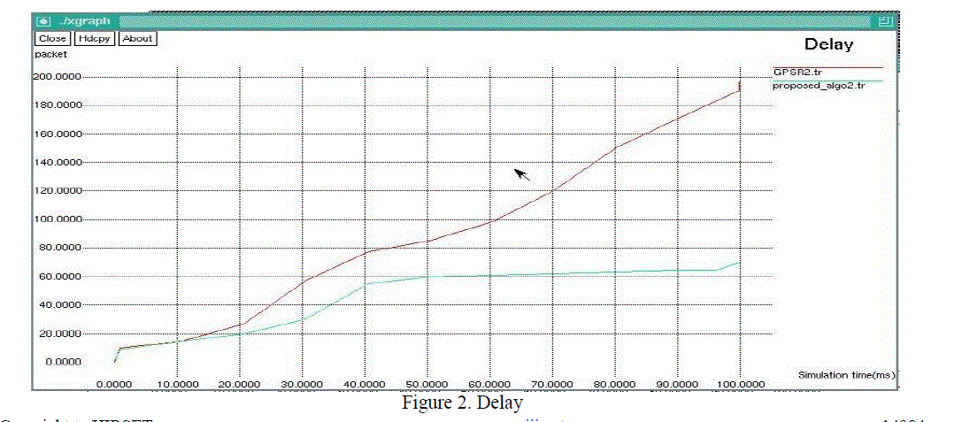
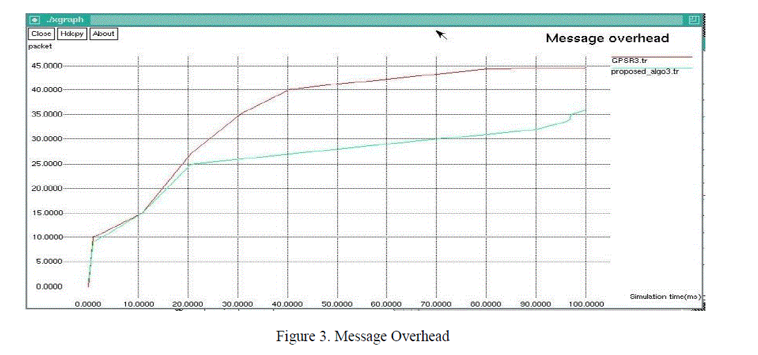
| For analyzing the performance of the proposed algorithm with respect to the GPSR, the different parameters like Delay, packet delivery, throughput, message overhead, safety message delivery etc. are measured against time (ms, 100/10) and packets used in the xgraphs. |
| The simulation results and the performance comparison are as follows: |
| Delay: Packet delay is the difference in end-to-end one-way delay between selected packets in a flow with any lost packets being ignored. The delay is compared in terms of time(ms) and packet. The xgraph shows that our proposed algorithm has less delay in comparison to the existing algorithm as shown by Figure 2. |
 |
| Message Overhead: Message Overhead is the no. of messages required to communicate with other mobile node to carry out the communication. The xgraph shows that our proposed algorithm requires fewer messages in comparison to the existing algorithm as shown by Figure 3. |
 |
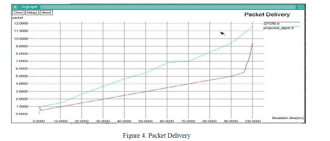
| Packet Delivery: Packet Delivery is the ratio of total sent packets and total received packets. The xgraph shows that proposed algorithm has more packet delivery in comparison to the existing algorithm as shown by Figure 4. |
 |
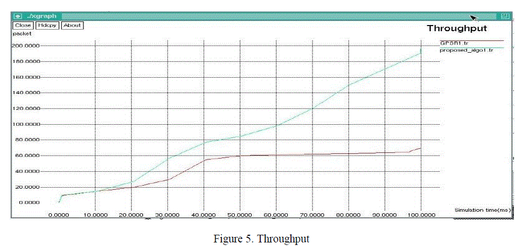
| Throughput: Throughput is the the sum of the data that are delivered to all terminals in a network. The xgraph shows that proposed algorithm has more throughput in comparison to the existing algorithm as shown by Figure 5. |
 |
VII .CONCLUSION AND FUTURE SCOPE |
| VANET have recently been the topic of extensive research due to its wide range of applications. Routing is the main component for success of VANET applications. There are lots of routing protocols designed especially for VANET. But most promising for urban scenarios are intersection based routing protocols. Designing of a routing protocol in urban environment must deal with traffic lights. This paper proposes an intersection based routing protocol that consider traffic lights. The algorithm is compared with existing GPSR in terms of Packet delivery ratio, delay and message overhead. The simulation results show that RLFF performs well in urban environment compared to GPSR. |
| There is a need of evaluating these techniques in a more realistic scenario and applying them to actual wireless scenario. There is a need of improving these schemes keeping in mind high speed of vehicles, frequently changing topology and large number of vehicles in city scenarios or in highway scenarios especially at the intersection, which will help in attaining future techniques in VANET like Intelligence in sensing the information, Intelligence in Communication. |
References |
|