ISSN ONLINE(2319-8753)PRINT(2347-6710)
ISSN ONLINE(2319-8753)PRINT(2347-6710)
P. Das Mohapatra1, B.B.Patra2 and B.B.Kar3
|
| Related article at Pubmed, Scholar Google |
Visit for more related articles at International Journal of Innovative Research in Science, Engineering and Technology
In the present study an attempt has been made to estimate the amount of heavy metals and pollutants getting accumulated in the ground water near the ash pond of thermal power plant near Talcher area, Angul. The study has been carried out keeping three season i.e. pre-monsoon, monsoon and post-monsoon. The chemical characterization of water samples have been carried out and are classified according to WHO guideline to estimate the impact of heavy metals and pollutants on ground water quality.
Keywords |
| Ash pond, thermal power plant, ground water, WHO guideline, heavy metals |
INTRODUCTION |
| Water being the vital element of life, maintenance of a good water quality is highly essential for human wellbeing. Ground water has several applications in the field of cooking, domestic uses, industrial applications, agricultural utility and many more. Due to its purity and rich nutrient and mineral contain, ground water is preferred as a major source in the form of purist form of water (1-4). With the rapid modernization and huge growth in population, the demand of water is increasing day by day which in turn leading to disposal of this water to different major water sources such as sea, river etc. which in turn is contaminated the ground water sources. Need of electricity for domestic as well as industrial use is enhancing day by day. To face this demand, generation of a huge quantity of electricity is found to be essential. In India the major sources for electricity generation through thermal power plant. Thermal Power Plant for electricity generation utilizes coal as the main source. In India availability of verities of coal has been made it possible for the existence of the thermal power plant. In the present study the area taken into consideration is Talcher, Angul which is 70.78 meter above the main sea level. It is located between the latitude of 20029’ and longitude of 34017’. The quantity of coal burn ash generated in this area is more than 172 Tons per year. The average rain fall is about 1123mm during monsoon. The areas under study are taken near by the thermal power plant by NTPC (TTPS) which is of 470 MW instillation capacities (5-8). In the present study samples have been collected over a period of one year i.e. 2012 during pre-monsoon (February-March), monsoon (June-July) and post-monsoon (November-December) seasons from the area nearby to the ash pond of thermal power plant. The ground water quality is being collected from the tube wells and wells available there by used for drinking as well as industrial and agricultural applications. |
II. MATERIALS AND METHOD |
| Water samples have been collected from different tube wells and other wells present near the ash pond area. The water level shows a drastically change from March to September i.e. adequate water get accumulated in the post-monsoon session due to heavy rain. The water samples were collected in stencilled bottles (polyethylene bottles). The test for pH, turbidity, water temperature and alkalinity has been carried out using multi functional water. The concentration of sodium and potassium are determined using Systronic Flame Photometer. The presence of temporary and permanent hardness is measured by EDTA method. Similarly the percentage of bio-carbonate is calculated by Bromo-cresol method whereas sulphate is done by gravimetric analysis and chloride by Mohr’s method. |
III. RESULT AND DISCUSSIONS |
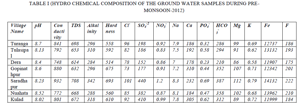
| The entire data obtained is being tabulated in Table-1, 2 and 3 as mentioned herewith. The analysis result for pre-monsoon, monsoon and post-monsoon season are represented in Table-1,2and 3 respectively, show that the water sample is always found to be alkaline in nature varies within a range of 7.3 to 9.19. |
 |
 |
 |
| The conductivity varies between 672-1282 moh/cm. the total dissolve solid is found to be in the range of 672-1282 mg/L. The TDS is found to be higher in post-monsoon which is attributed to be the accumulation of fly ash contaminated waste water into the ground water sources. The variation in alkalinity is between 201-372 mg/ L is slightly higher than the permissible limit whereas the nitrate contain is found to be between 0.78-8.3mg/L which is permissible as per the Who guideline. The variation in hardness, calcium, magnesium and sulphate are found to be higher than the permissible limit which may be attributed to the contamination of fly ash loaded surface water accumulated in ground water. The ranges are306-732 mg/L in hardness 116-377mg/ L in calcium, 67.2-200mg/L in magnesium and in sulphate the range is varies from 102-440 mg/L. The TDS gradually increases from pre-monsoon through monsoon to post-monsoon level which is attributed to the fact that with the rise growth in the plant, the variation in TDS has an adverse effect on the soil characteristics which in turns leads to the formation of insoluble complex compound that decreases the nutrients intake of the plant. The chemical analysis data for other parameters such as sodium, potassium and iron are found to be in the range of 7-10.42 mg/L,0.58-1.45 mg/L and 8221-15051 mg/L in iron respectively which may be due to the leaching of these nutrients more into the waste sources due to the increase in the pH level of the water. In case of Fluoride, it varies from 73-327 mg/L. |
IV. CONCLUSION |
| The above study concluded that the ground water sources near by the ash pond are getting highly contaminated due to the leaching of different metals and toxic elements into the ground water sources. Keeping in view the health of plants, animals and human beings adequate measures are to be taken to get rid of ground water pollution. |
References |
|