International Journal of Advanced Research in Electrical, Electronics and Instrumentation Engineering
ISSN ONLINE(2278-8875) PRINT (2320-3765)
ISSN ONLINE(2278-8875) PRINT (2320-3765)
Mohammad Ehsan Salavati1, Ali Ebrahimi2, Maryam Rezaee3, Hamid Reza Rasouli4
|
| Related article at Pubmed, Scholar Google |
Visit for more related articles at International Journal of Advanced Research in Electrical, Electronics and Instrumentation Engineering
Identification tags ( dog tags) for soldiers appear to be one of the most under-studied and neglected areas of research. In battles the only identifying object is a metal identification tag that has the information about the soldier worn it. To find and identify those killed, the entire war zone have to be searched to find dead bodies or these identification tags. This task is not only time-consuming but also costly and needs a lot of manpower to search the area. In this paper an electronic device is designed and implemented to replace identification tags and to help finding killed or injured soldiers as soon as possible during the war or after it. A light, power efficient and robust positioning module that provides a high accuracy in all environments is needed to find soldier position. Although GPS has weaknesses but it can provide sufficient accuracy while meeting the above requirements. RF transmission is used to send data to operation center. And a low consuming 32 bit ARM microcontroller is used for circuit timing and data processing as well as keeping soldier basic and medical information. The battery life of this device is important. All the electrical equipment used in this device is low power consuming and with the written algorithm the device can work for months.
Keywords |
| Identification tag, Positioning, GPS, RF transceiver, circuit, war casualties |
INTRODUCTION |
| During the 3400 years of human life on earth, man has only lived 250 years in peace. During this time, 14500 wars have been occurred and 150 of them were after the foundation of the United Nations and over 101 million people have been killed since 17th century. The war between Iran and Iraq was the longest conventional war of the twentieth century. The casualties of this war were 213255 dead and 11697people missing presumed dead. Finding and identifying the dead during the war or after that is a difficult time-consuming task. Still after 20 years of Iran-Iraq war, more dead soldiers are found and added to the number above [1, 2]. |
| To find and identify those killed; the entire war zone has to be searched to find dead bodies or identification tags they were carrying. This task is not only time-consuming but also costly and needs a lot of manpower to search the area. In addition, after a while rotten bodies or skeletons are not identifiable. DNA testing is a method of identifying but it’s not applicable in all cases. Now after more than 20 years of Iran-Iraq war, the search for missing bodies still continues and every now and then more dead are found [3]. |
| In this paper an electronic device is designed and implemented to replace identification tags to help finding killed or injured soldiers as soon as possible during the war or after it. This circuit will send the exact location of the casualties to the base operation center. Also a push button is added to the circuit in case of injury and enemy attacks or need for help. So that the soldier can ask for help by pushing this button and in base center the exact location of the soldier will be received. |
| Advantages of having a device like this are as follows: |
| 1- Reducing the time-consuming process of searching every inch of the area to find the dead |
| 2- Reducing themanpowerneededfor local search |
| 3- Ability toask for helpwhen needed |
| 4- Finding theexact location of thedead orinjured |
| 5- Transportation of the deadandwounded out of war zone as soon as possible |
| 6-Quickhelptothe injured soldieras soon aspossible |
| 7- Quick access to the electronic medical records and information of each soldier in case of need for help |
| 8- Knowing the position of soldiers during the operation and after the operation |
RELATED WORK |
| Nowadays there are various methods for positioning. These include positioning by GPS [4-10], RFID [11-16], using telecommunication networks [17-19], combining GPS and GSM [18, 20], assisted GPS [18, 21] other shortrange positioning systems [22]. |
| In general, none of these modern technologies are able to provide a cheap, fast and available method for positioning in all areas and all have some advantages and weaknesses. Therefore, each of these methods is used according to their application and requirement. Using GPS is still the best and most applicable way for positioning that covers all around the earth in every weather condition. Beside availability, its modules are cheap, light and accurate enough for our purpose. The main disadvantage of GPS is that it does not work indoors. |
| This device consists of two units; soldier unit and operation center unit. In soldier unit, a RF transmitter module is used to send data to operation center. And a low consuming 32 bit ARM microcontroller is used for circuit timing and data processing as well as keeping soldier basic and medical information. In operation center unit, a RF receiver is used to get the transmitted data, an ARM microcontroller is used for processing data and a characteristic LCD to show the position coordinates and messages received. Also LEDs in both circuits are used to show the working status of the circuits. |
BASIC CONCEPT |
| As the main goal of this device is to replace identification tags and to help finding dead soldiers, the written algorithm is based on this matter. It is assumed that the dead soldier is in a fixed position without moving. Hence, it is not necessary to transmit the body position repeatedly every second. The soldier unit starts every one hour. At every turn, GPS finds the position of the soldier and the position data is transferred to the microcontroller through UART port. After evaluating the data and its validity, the position of the soldier is extracted and sent to RF transmitter to be sent to operation center. |
| Then, the circuit is turned off and after one hour it is turned on and the above steps are repeated. After extracting the soldier position coordinates, it is compared to the previous coordinates. If the position hasn’t changed according to the previous position, the next turning on time is doubled. This means that if the position does not change, the circuit will turn on after 2, 4, 8, 16 and finally 24 hours. Therefore, if the dead body does not move, its position will be transmitted once in everyday and for a long time. This approach increases the battery life and device will transmit the body coordinates for months. If the position changes again, the circuit timing will be every one hour again. |
| In each time when GPS is trying to find the position, microcontroller waits 200 seconds for valid data from GPS. If it receives no valid data, the message “NO SAT” will be transmitted which means GPS could not find enough satellites to receive data. After that the circuit is turned off till the next routine time and will not enter an infinite loop to find the position. |
| A push button is also mounted to the circuit in case of need for help. This button is used when the soldier is in need for help during the battle. These may include injuries, getting caught in a difficult situation, enemy attacks, chemical and biological attacks and etc. In all these situations, after pushing the button, the device will find the exact position and transmit it to operation center to send help. The message “HELP ME” with soldier position will be shown in the receiver unit in operation center. Since it is known who has requested for help, the medical records of the soldier is available for the rescue team, specially the information they need such as blood type, health condition and history of inoculations. This information is also stored in each device microcontroller as it is a replacement for identification tags. |
EQUIPMENT USED IN THIS PROJECT |
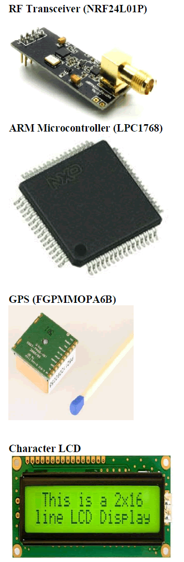
| The nRF24L01 is a single chip 2.4GHz transceiver with an embedded baseband protocol engine (Enhanced ShockBurst™), designed for ultra-low power wireless applications. It uses GFSK modulation. It has user configurable parameters like frequency channel, output power and air data rate. It needs only 11.3mA TX at 0dBm output power and 12.3mA RX at 2Mbps air data rate, only 900nA in power down and it has On chip voltage regulator. |
| The LPC1768 is an ARM Cortex-M3 based microcontroller for embedded applicationsrequiring a high level of integration and low power dissipation. The ARM Cortex-M3 is anext generation core that operates at up to a 100 MHz CPU frequency. The peripheral complement of the LPC1768 includes up to 512 KB of flash memory, 64 KB of data memory, a USB interface, 4 UARTs, , SPI interface, 12-bit ADC, 10-bit DAC, ultra-low power RTC with separate battery supply, and up to 70 general purpose I/O pins. |
| FGPMMOPA6B is a MediaTek Single Chip GPS module, small with 16mm x 16mm x 6mm dimension. It has high sensitivity up to -163 dBm tracking and superior urban performances. It has the position accuracy about 3m. Cold start in under 35 seconds and hot start is under 1 second typically. With only 48 48mA at acquisition and37mA at tracking, it is a low power consuming module. |
| This is a basic 16 character by 2 line display with black text on green background. It utilizes the extremely common HD44780 parallel interface chipset. |
 |
IMPLEMENTATION |
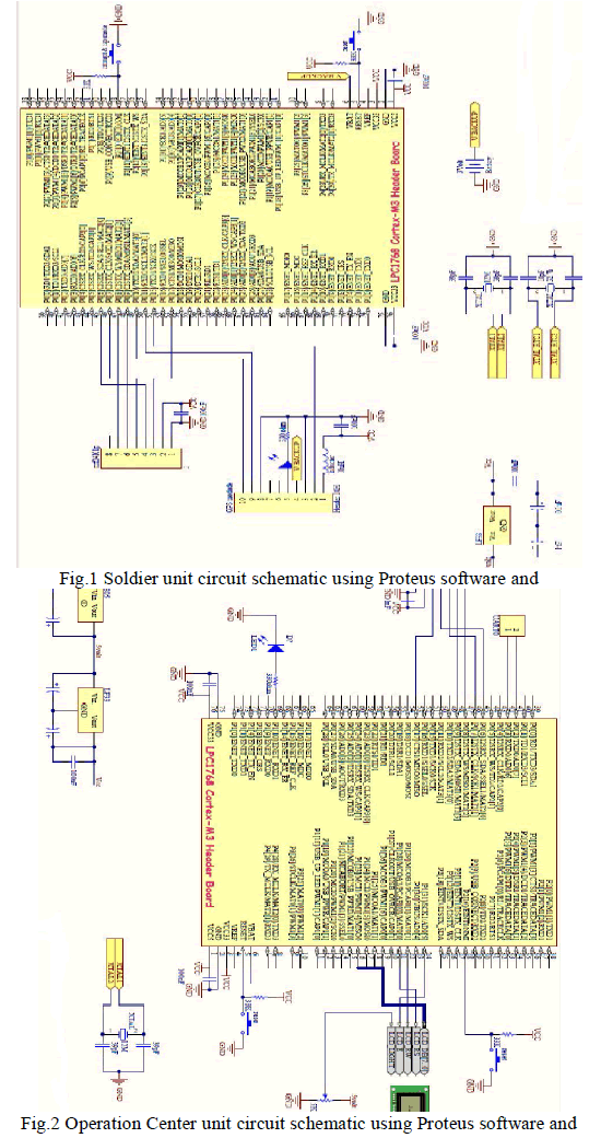
| Fig.1 and fig.2 show the schematic of this circuit for soldier and operation center respectively. For simulation and drawing schematics we used Proteus software. The codes for microcontrollers in operation center unit and soldier unit are written in C language with Keil software. |
 |
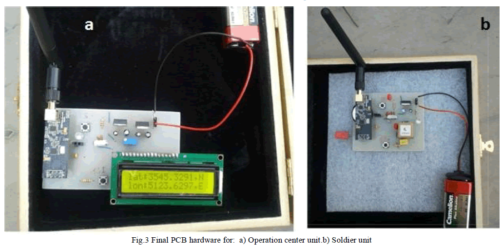
| After implementation of the circuits on breadboards and testing the performance of the device, the components were mounted on PCB. The hardware results are shown in fig.3. For both circuits, a 9V battery is used. One power regulator is used in soldier unit to supply 3.3V for microcontroller and GPS module. On the other hand two regulators are used in operation center unit; one for 5 V LCD and one for 3.3V microcontroller. |
 |
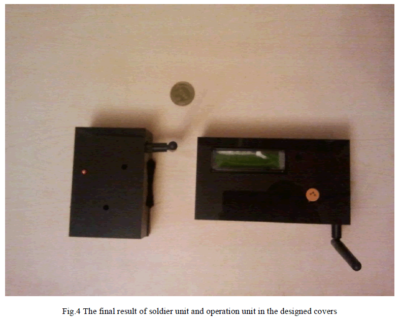
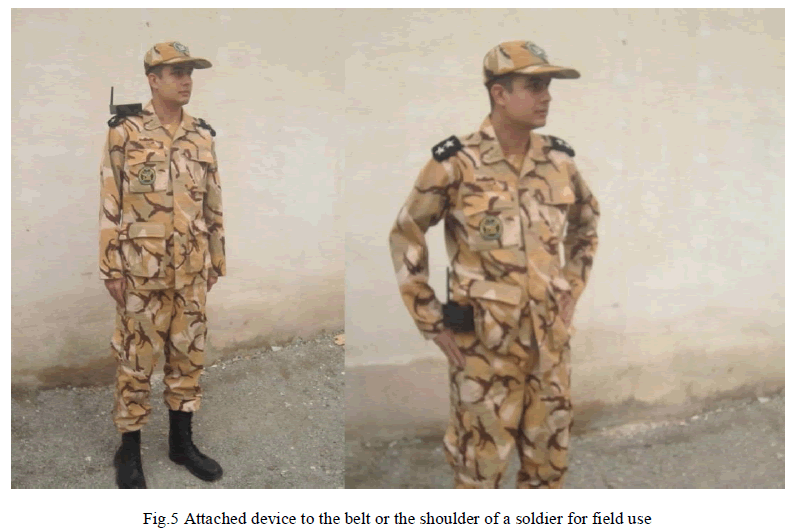
| For the use in the field, a cover was designed and made for both units. In fig.4, the soldier unit and operation center unit are shown. With this cover, the soldier unit can be attached to the belt or the shoulder of soldier which is shown in fig.5. |
 |
 |
RESULT |
| In order to test the performance of the device easily, we slightly changed the algorithm. Instead of turning on every one hour, it is done in every one minute. If the coordinates do not change, this time will be increased by one minute each time and up to 6 minutes. Therefore we do not need to wait hours to test the performance of the circuit. |
| The circuit was tested in 3 conditions: 1) in open space away from buildings, 2) in urban area and among buildings such as streets and back yards, 3) indoors near a window. The results are as follows. |
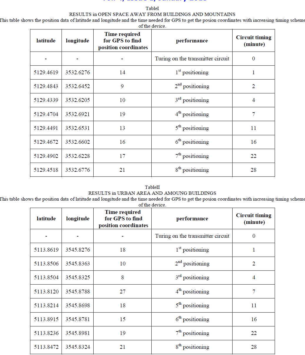
Results in open space far away from buildings and mountains: |
| The results of testing the circuit in open space away from buildings are shown in table1. One minute after turning on the soldier unit, GPS will receive data and as expected, it took less than 35 seconds for cold start for positioning. As can be seen in table 1, because the position of the device didn’t change, the circuit was turned off and on in increasing time schedule by one minute each time. As the accuracy of GPS modules are about 3 to 5 meters and sometimes up to 25 meters, the position coordinates are not exactly the same even if the position of the device does not change. Therefore after examining the data received by GPS, we found out that the change in the first number after the decimal point shows the change of distance up to 30 meters. Hence, if the first number after the decimal point and the other 4 numbers before that do not change, the microcontroller consider no change in position and increase the time of the next start by one minute. |
| The performance of “help” push button was also tested in different distances and it showed excellent performance and after transmitting the coordinates in each time, the circuit performed well again according to its timing routine. |
Results in urban area and among buildings |
| This time the performance of device was tested in urban area and among building such as streets or back yards. The results are shown in table2. As can be seen, the results show that the time required for GPS positioning is not very different than acquisition time away from buildings in open space. The device showed good performance in urban area. These results were obtained in cloudy and rainy weather which shows the acceptable performance of the circuit in poor weather conditions. |
 |
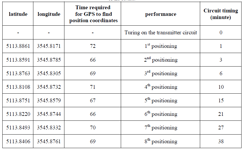
Results of indoors near a window |
| The third condition the device was tested was in closed environment and indoors near a window. The results of this test are listed in table 3. As can be seen, GPS module required more time for receiving data from satellites than two previous conditions. And if the window is surrounded by other buildings and receiving data from satellites take more than 200 seconds, the “No Sat” message is transmitted to show inability of finding enough satellites. |
| TableIII |
RESULTS of INDOORS AND NEAR A WINDOW |
| This table shows the position data of latitude and longitude and the time needed for GPS to get the posion coordinates with increasing timing scheme of the device. |
 |
CONCLUSION AND DISCUSSION |
| In this paper a device was designed and implemented in order to replace identification tags and to help fining casualties in battles and wars. Using this device will be a great help in the time-consuming and difficult task of finding dead soldiers during the war or after that. Also this device stores the soldier basic and medical information and can be used to ask for immediate help when needed. |
| GPS was used as it is yet the most applicable positioning system that covers all around globe in every weather conditions. The FGPMMOPA6B GPS module used for this purpose because it has low power consumption, good accuracy and small dimensions. LPC 1768 ARM microcontrollers were used for processing and timing of the soldier unit and operation center unit. NRF24L01 transceiver modules were used for transmitting and receiving position coordinates and messages. All the modules used in this project were power efficient and with the written algorithm the device can work for a long time. |
| The soldier unit was tested in 3 conditions: 1) in open space away from buildings, 2) in urban area and among buildings such as streets and yards, 3) indoors near a window. The results showed the acceptable performance in all 3 conditions and also in poor weather conditions. The starting and acquisition time was less than 30 seconds in open space and in urban area. In indoor environment it took longer which is normal. Also a “help” button was mounted on the device in order to ask for help and send the exact coordinates of the soldier in need when the button is pushed. |
| This device is a prototype. By adding more instruments, the use of this device can be expanded. For example biosensors can be added in order to monitor the health condition of the soldier and transmit the data to the operation center. The RF transceivers can be used for real time navigation and orientation of soldiers and many more recent technologies to monitor the overall situation of the soldier during and after the battle. |
References |
|